Get Full Government Meeting Transcripts, Videos, & Alerts Forever!
Monroe County GIS team unveils housing-inventory dashboard to help planning decisions
Summary
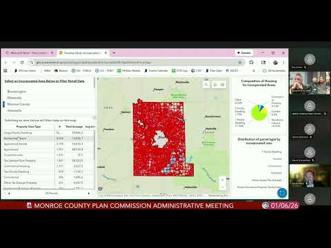
Monroe County staff presented a publicly available GIS dashboard that combines parcel geometry, assessor attributes and census data to map existing housing types and vacant parcels; staff said the tool will help planners and the public identify vacant land vs. vacant structures and refine policy choices.
Monroe County’s GIS division demonstrated a new housing-inventory dashboard during the Plan Commission’s January administrative meeting, saying the tool pulls parcel geometry from county records and attribute data from the assessor and auditor to show the county’s housing composition and vacant parcels across jurisdictions.
“Parcel data are the geometry of parcels in Monroe County,” said John Baton, the county’s GIS coordinator, who led the demonstration. He explained the dashboard groups assessor property-class codes (for example, single-family classes 5-10 through 5-14) and overlays address points and American Community Survey estimates to better represent housing units than parcel counts alone.
Baton highlighted examples for Bloomington neighborhoods, where the…
Already have an account? Log in
Subscribe to keep reading
Unlock the rest of this article — and every article on Citizen Portal.
- Unlimited articles
- AI-powered breakdowns of topics, speakers, decisions, and budgets
- Instant alerts when your location has a new meeting
- Follow topics and more locations
- 1,000 AI Insights / month, plus AI Chat