Monroe County GIS team unveils housing-inventory dashboard to help planning decisions
Get AI-powered insights, summaries, and transcripts
Subscribe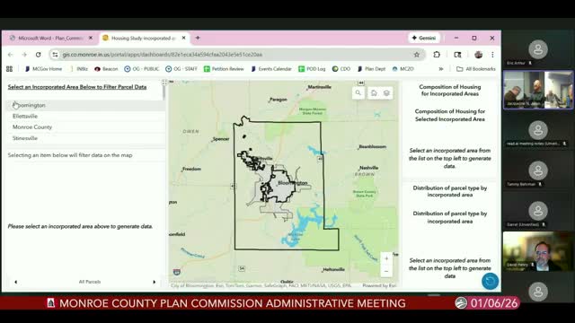
Summary
Monroe County staff presented a publicly available GIS dashboard that combines parcel geometry, assessor attributes and census data to map existing housing types and vacant parcels; staff said the tool will help planners and the public identify vacant land vs. vacant structures and refine policy choices.
Monroe County’s GIS division demonstrated a new housing-inventory dashboard during the Plan Commission’s January administrative meeting, saying the tool pulls parcel geometry from county records and attribute data from the assessor and auditor to show the county’s housing composition and vacant parcels across jurisdictions.
“Parcel data are the geometry of parcels in Monroe County,” said John Baton, the county’s GIS coordinator, who led the demonstration. He explained the dashboard groups assessor property-class codes (for example, single-family classes 5-10 through 5-14) and overlays address points and American Community Survey estimates to better represent housing units than parcel counts alone.
Baton highlighted examples for Bloomington neighborhoods, where the dashboard shows about 53% of housing classified as single-family dwellings, roughly 20% as condos and approximately 3.5% listed as residential-vacant in assessor records. He cautioned that short-term rentals such as Airbnbs are handled inconsistently: if an owner or manager has registered a property as a rental with the city it may appear as such, but many short-term rentals are not separately tracked in assessor files.
The presentation also included countywide tallies: Baton reported 3,536 parcels coded as residential-vacant, 1,121 commercial-housing parcels (with 1,196 address points), and a condo classification that covers several thousand parcels. He explained that a single apartment parcel can contain many address points, which affects unit and population estimates used for school redistricting and other planning tasks.
Commissioners asked whether zoning and permit status could be integrated. Baton said topology and zoning layers are the obvious next steps: “If we wanted to click on one of those parcels right now, we know what classification the assessor has — but, we don’t yet have the zoning lines integrated,” he said, adding that the county is working with the auditor, assessor and technical-services staff to assemble authoritative layers.
Baton said the dashboard publishes nightly updates from aggregated source datasets and that the county participates in the state’s annual data-harvest program that supplies core datasets for Next Gen 9‑1‑1. He also noted the GIS division published an American Community Survey dashboard covering 2018–2023 five-year estimates the same day, and that the housing dashboard is already public on the county’s Beacon/Elevate parcel viewer with plans to surface it more widely.
Staff and commissioners asked for a few follow-ups: differentiate vacant lots with no structure from vacant properties with existing but unoccupied structures; add permit and approval status (PUDs and plats) so the dashboard can reflect approved-but-not-built units; and produce a short analysis of how many recent variance requests the proposed accessory-structure exception would affect. Baton and staff agreed to return with those clarifications.
The plan commission closed the hour-long inventory discussion by thanking Baton and noting staff will continue to refine data quality with the assessor and auditor offices.