Health department unveils new PFAS map; MassDEP data pending from recent island sampling
Loading...
Summary
Nantucket’s environmental contamination administrator announced a new public map showing point PFAS detections (including low‑level 'detects') and said MassDEP sampled several areas in December; the board was urged to encourage regular well testing and to view the map as part of transparency efforts.
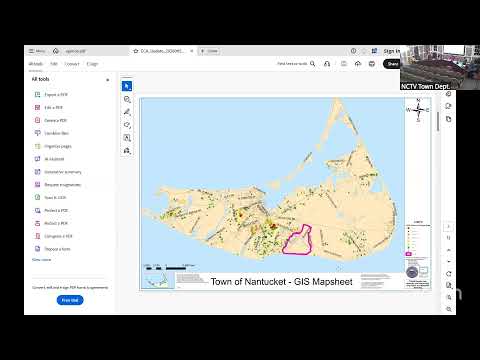
The board received a monthly PFAS update on Jan. 15 and a new public map designed to show specific detections rather than merged half‑mile buffers.
Andrew Shapiro, the environmental contamination administrator, said the health department has processed roughly 500 samples island‑wide (MassDEP and town data), and that since December the department logged 27 new samples with five detects below the state standard and five non‑detects for the PFAS‑6 suite. He said MassDEP conducted targeted sampling in mid‑December in areas including Filling Mill and near Hammock Pond and Oak Hollow; those lab results are pending.
Shapiro explained the map’s color coding: red indicates properties exceeding the state 'imminent hazard' threshold, orange properties exceeding the state standard (20 parts per trillion for PFAS‑6), yellow detects below the standard, and green nondetects. He said the new map aims to improve transparency and to show where lower‑level detects have appeared.
The board announced an online public information session on PFAS sampling and surface‑water work and circulated a fact sheet on selecting water filters.
Why it matters: PFAS contamination is a potential drinking‑water and environmental concern on the island; point detections guide testing priorities and public outreach.
What’s next: MassDEP lab results from December sampling; ongoing posting of town and MassDEP data on the health‑department map and a public information session this week.
Provenance: PFAS update and map description SEG 4003–4120; MassDEP sampling comments SEG 4012–4018; public information session announcement SEG 4122–4132.