Get Full Government Meeting Transcripts, Videos, & Alerts Forever!
Get email alerts on the Residential Subdivision Estate topic
No spam. Unsubscribe anytime.
Agency approves rezoning to permit equal inheritance division for 20.14-acre Sanderson parcel
Summary
The agency approved Ordinance 2025-28 to rezone a 20.14-acre parcel owned by Gracie White from AG-7.5 to AG-5 so it can be divided among four heirs; board discussed access, easement layout and emergency-service turnaround needs.
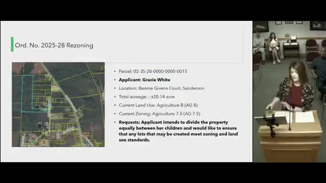
Baker County Land Planning Agency voted Thursday to rezone a 20.14-acre parcel in Sanderson (off Benny Givens Court) from AG-7.5 to AG-5 so the owner can divide the land equally among four children as part of estate planning.
Planning staff said the parcel, owned by Gracie White, has a current land use of AGB and is zoned AG-7.5. Staff explained that under current AG-7.5 zoning the tract could not be divided equally into four conforming parcels by deed (rather than family-lot procedures), and that the AG-5 zoning would allow four roughly equal five-acre parcels. The planner showed aerials and explained that access to Benny Givens Court comes from Gaskin Circle and does not directly front State Road 229.
Board members probed access and emergency-service concerns after staff described a center easement that would run up the lot’s middle and provide access to the rear parcels. A board member asked whether the easement width and placement would leave each lot large enough to meet setbacks; staff replied that one parcel would retain the easement while the others would have access rights, and that all resulting parcels would remain five acres or larger. The transcript records a single easement width as “38 foot.”
Board members also discussed the county’s updated flood maps; staff said flood-map updates are in progress and that the emergency-management office is conducting H&H (hydrology and hydraulics) studies but gave no firm status. The board asked the owner and family representatives to consult the fire chief’s guidance on turnaround and emergency access; staff volunteered to provide the fire chief’s access/turnaround requirements to the applicant’s surveyor.
A person identifying themselves as a family member confirmed on the record that the divided parcels would remain family property and that the access would come through their portion of the land. After discussion the board moved and seconded approval of Ordinance 2025-28; the motion carried on the record as “aye.” Staff said the board’s comments and the fire-chief guidance would be included when the matter is presented to the Board of County Commissioners.
The rezoning is intended to create conforming five-acre lots for inheritance; no development plans, permits or building proposals were filed at the hearing.