UDOT names Alternative B preferred for Heber Valley Corridor EIS; warns of wetland trade‑offs
Get AI-powered insights, summaries, and transcripts
Subscribe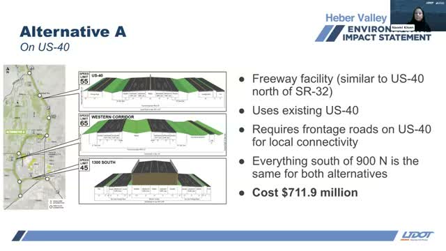
Summary
The Utah Department of Transportation (UDOT) identified Alternative B as the preferred option in the draft Heber Valley Corridor EIS, citing about 15% faster regional travel and fewer relocations but substantially greater wetland impacts; UDOT pledged limited access and prioritized wetland mitigation in the Northfields.
The Utah Department of Transportation (UDOT) said it has identified Alternative B as the preferred build option in the draft Heber Valley Corridor Environmental Impact Statement, concluding that the route would deliver better regional mobility and reduce traffic pressures on downtown Heber while posing larger impacts to wetlands and farmland.
“UDOT has identified Alternative B as the preferred alternative,” project manager Craig Hancock said, explaining the decision rests on transportation performance and community objectives. UDOT’s technical team presented modeling that shows Alternative B provides roughly 15% faster travel times on the new corridor and removes more regional and truck traffic from Main Street.
The presenters gave specific comparisons: travel from SR‑32 to US‑189 is projected at about 7 minutes 25 seconds under Alternative A versus about 6 minutes 15 seconds under Alternative B, and similar route‑level improvements were shown elsewhere. Those operational benefits, the team said, translate into fewer failing intersections on Main Street, shorter queues and better local operations.
But the preferred choice carries trade‑offs. The draft EIS quantifies environmental and property effects: Alternative A would affect about 23 acres of aquatic resources (including wetlands), impact four historic buildings and require roughly 27 residential or business relocations. Alternative B would affect about 54 acres of aquatic resources, impact one historic building and require roughly eight relocations. The present‑day estimated costs provided in the draft EIS are about $711.9 million for Alternative A and $760.5 million for Alternative B.
Naomi Lisonbee, UDOT’s environmental program manager, described how mitigation would be handled under federal permitting: “Those ratios usually start at the very low end at 2 to 1 if you’re creating a new wetland and tend to go up from there,” she said, noting the U.S. Army Corps of Engineers determines final compensation ratios under the Clean Water Act permitting process.
UDOT staff also announced two programmatic commitments in the draft document intended to limit induced development and reduce long‑term harm to the Northfields. First, the corridor would be designed as a limited‑access facility under UDOT jurisdiction; no access would be allowed beyond the interchanges identified in the draft EIS between Potter Lane/College Way and SR‑113. Second, UDOT said it will “strive to mitigate up to 100% of the impacts” to wetlands and will prioritize mitigation within the Northfields where watershed boundaries and willing sellers allow.
Staff emphasized the distinction between local and regional mobility in the analysis: by routing regional through‑traffic onto the new corridor, Main Street could be repurposed to align with Heber City’s historic‑town‑center vision for lower speeds and improved pedestrian and bicycle facilities.
UDOT also presented design features that reduce direct impacts to local access — frontage roads, grade‑separated interchanges and a 12‑ft paved multiuse trail alongside the corridor — and outlined where elevated sections, ramps and underpasses would be used.
The draft EIS lists noise and other resource impacts and identifies noise barriers that met feasibility and reasonableness criteria. Decisions about constructing noise walls would be finalized in the final design and would be subject to resident balloting for affected properties.
UDOT urged reviewers to consult the draft EIS appendices and interactive maps for parcel‑level right‑of‑way tables, visual simulations and technical reports, and encouraged formal comments during the public comment period so staff can address concerns in the final document.
The team said it will publish the final EIS and a Record of Decision after the comment period, with the schedule tied to permitting and future funding allocations.
What’s next: the draft EIS remains open for formal public comment through the period stated on the project website; staff said they expect to respond to comments in the final EIS and to publish a Record of Decision in the next phase of the process.