Get Full Government Meeting Transcripts, Videos, & Alerts Forever!
Get email alerts on the Transportation Interchange topic
No spam. Unsubscribe anytime.
Regional planner pitches $50 million concept to reconfigure I‑384/Route 6 interchange in Bolton
Summary
A regional transportation planner presented a lower‑cost concept to reconfigure the I‑384/Route 6/Notch Road interchange to restore full vehicle and trail access, improve bike/pedestrian crossings and reduce some bridge costs; the town will seek public input before sending support to DOT.
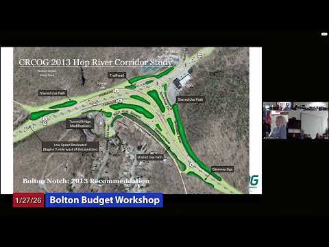
Rob Alouise, director of transportation for the regional planning agency, presented a concept plan to the Bolton Board of Selectmen on Jan. 27 proposing a reconfiguration of the I‑384/Route 6/Notch Road interchange intended to restore full directional access and add a new trailhead connection.
Alouise framed the problem as limited connectivity: Bolton is bisected by I‑384 and Route 6, and access between the southern and northern parts of town now relies on a few constrained links. He said prior studies proposed full reconstruction but were rejected by state DOT as too costly; the earlier reconstruction idea was described in the presentation as exceeding $80 million. “We estimate this to be in the $50,000,000 range,” Alouise said, presenting a design that would make Route 6 the through movement, extend Route 44, realign Notch Road to a signalized intersection and use shorter bridges rather than a long flyover.
Alouise said the concept would also include a protected bike/pedestrian phase across the on‑ramp and a trailhead on town property to improve access to the Hot River Trail. He noted the concept files include capacity analyses but that traffic counts would be updated before any formal submission to DOT and that state law requires an intersection control evaluation during project development. “This is just a concept,” Alouise said, emphasizing the design is preliminary and subject to DOT review and environmental and design processes.
Board members and attendees asked about operations, level‑of‑service (LOS) projections, bridge heights and right‑of‑way impacts. The presenter said the proposed southern intersection would perform at LOS B now and under a 25‑year traffic projection, and confirmed that an existing bridge structure would be replaced with two shorter bridges at roughly the same height as today. He also acknowledged that at least one apartment would likely require land acquisition and relocation under DOT policy, and that those costs were included in the mid‑$50 million estimate.
Bruce (identified as the town fire chief) raised a safety concern about bringing traffic off I‑384 at highway speeds into a new signal, saying, “Coming off 384 at 60 miles an hour coming to a stoplight would be interesting.” Alouise and the board said the town would hold additional public meetings and gather community input before deciding whether to send a letter of concept support to DOT; if the town provides conceptual support, Alouise said the agency would request a pitch meeting with DOT chief engineers to seek formal concept‑development review.
The proposal and supporting materials will be posted on the town website later that week, Alouise said. The board repeatedly stressed that specifics would be finalized through DOT’s environmental and design review processes and by later public meetings.