Get Full Government Meeting Transcripts, Videos, & Alerts Forever!
Get email alerts on the Land Use Village Center topic
No spam. Unsubscribe anytime.
Swannanoa steering committee narrows village center boundaries, debates higher density and affordable‑housing linkage
Summary
Steering committee members backed expanding the Village Center boundaries near US 70 to New Salem and asked staff to study raising the upper density limit (including an option to 40 units/acre) tied to affordable‑housing incentives; staff will review feasibility, parking, and flood/stormwater constraints.
The Swannanoa Steering Committee in Buncombe County agreed in principle to expand the proposed Village Center at the US 70/Warren Wilson Road area and asked staff to study higher density options tied to affordable‑housing incentives.
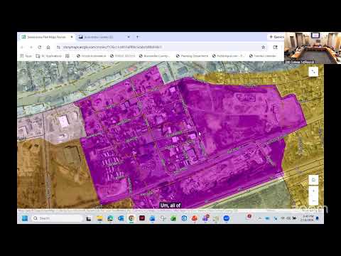
At the meeting facilitator S1 presented draft map changes informed by recent design workshops and said, “We are now shooting for a September adoption date instead of August,” then reviewed the Village Center proposal and where staff had highlighted proposed expansions.
Committee members described parcel boundaries and local conditions. S9 urged using a clear property line as the western cutoff near a red barn; S3 and others pressed for New Salem to be the eastern cutoff near ArtSpace and the cluster of businesses residents called the “6 pack.” When S1 asked for objections to adopting New Salem as the cutoff, no one objected and staff recorded consensus.
The group spent substantial time on density and housing policy. Staff (S2) explained how density‑bonus programs currently work, saying the county’s density bonuses “kick in at 20% affordable” units and recommended keeping general language on the map while putting precise targets into implementation policies. Several participants (S3, S4, S9) proposed raising the Village Center upper density limit to 40 units per acre — matching a proposed walkable‑destination cap — to encourage denser affordable development. Opponents warned of practical constraints including parking requirements, stormwater controls and steep slopes.
S2 cautioned that the map sets guidance while implementation would use programs and overlays: “These numbers are up for discussion,” S2 said when asked whether changing an upper limit would automatically permit taller or denser buildings. The committee placed a “parking‑lot” action for staff to return with feasibility options (including the 40‑units/acre scenario), and to make clearer links between density limits and the county’s incentive programs.
Next steps: staff will incorporate the agreed boundary changes into the next map draft, research feasibility of higher density in candidate parcels, and present options for how affordable‑housing percentages would interface with density bonuses at a future meeting.