Get Full Government Meeting Transcripts, Videos, & Alerts Forever!
Get email alerts on the Travel Demand Model topic
No spam. Unsubscribe anytime.
Consultant outlines Nantucket travel‑demand model; staff plans June demo and joint meeting with Select Board
Summary
Consultant Sudhir Murthy of TrafInfo presented a plan to adapt the statewide CTPS travel‑demand model for Nantucket, adding local highway links, ferry seasonality and household‑level detail; staff said a base model demo is expected by June and recommended a joint Select Board meeting to set scenarios.
Sudhir Murthy of TrafInfo told town staff and the chair that TrafInfo will adapt the Boston-region Central Transportation Planning Staff (CTPS) model to create a travel‑demand forecasting tool tailored to Nantucket. The model will simulate travel at the household level and estimate future traffic volumes, vehicle‑miles traveled, air‑quality and greenhouse‑gas effects, Murthy said.
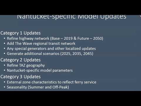
Murthy said the team will not start from scratch but will extract and refine the statewide model for Nantucket, adding local highway links, a regional transit network, special generators such as the airport and nearby industrial users, and intermediate forecast years between the statewide base (2019) and long‑range year (2050). "We want to have a model that would allow for both off peak and summer peak," Murthy said, noting the island's strong seasonality and ferry service.
Staff said the project was funded by a town‑meeting appropriation in 2019 and that a working base model demonstration will be ready by June. "A good demonstration of the base model will be ready, by June," an unidentified staff member said. The staff recommended a joint meeting with the Select Board to identify scenario growth rates and to incorporate recently developed build‑out GIS files for scenario bands to 2045 and 2050.
The model is designed to be used for standard planning and engineering tasks: generating future traffic and intersection volumes for analysis software such as Synchro; assessing how proposed developments change volumes, vehicle‑miles traveled and local air quality; and testing travel‑demand‑management strategies to reduce single‑occupant vehicle trips and increase transit, walking and biking. Murthy described the forecast as household‑level, accounting for household size, numbers of workers, children and elderly residents, and incorporating modes including transit, park‑and‑ride, rideshare (TNCs), work‑from‑home, walking and biking.
During questions, Select Board member Hillary asked whether the town could use the model instead of hiring outside traffic consultants for development impact work. Staff said the model can, in many cases, generate volumes and other inputs in‑house and be used in partnership with an applicant's traffic consultant, but TrafInfo would not be expected to write applicants' traffic‑impact assessment reports. Murthy added that the tool can simulate lane counts and directional changes to evaluate proposals such as making a street one‑way or adding a connector road.
Staff and the chair concluded the discussion by thanking Murthy and committing to coordinate the Select Board meeting and the public presentation of scenario results. The presentation closed with staff indicating further public demonstrations and scenario testing later this year.