Get Full Government Meeting Transcripts, Videos, & Alerts Forever!
Get email alerts on the Public Safety topic
No spam. Unsubscribe anytime.
Montgomery Township GIS spotlights Fire Department Activity Dashboard for Fire Prevention Week
Summary
Montgomery Township GIS demonstrated a Fire Department Activity Dashboard during Fire Prevention Week, showing incident, inspection and community risk reduction data on a central map and explaining how residents can request services; the dashboard updates monthly.
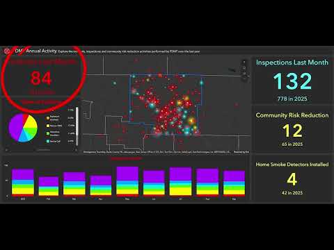
GIS Jen of Montgomery Township GIS highlighted the township’s Fire Department Activity Dashboard during a GIST segment for Fire Prevention Week, describing how residents can view incidents, inspections and community risk reduction activity on the township website.
The dashboard centers on an interactive map that displays point data for three types of fire department activity and visual indicators that show the previous month’s activity and a running total for the year, GIS Jen said. Pie charts present year-to-date totals by type and a bar graph breaks activity down by month.
The dashboard uses a color scheme to distinguish activity: red points and indicators represent incidents the department was dispatched to; blue denotes inspections undertaken to confirm buildings meet the 2018 International Fire Code; and yellow marks community risk reduction work. GIS Jen listed examples of community risk reduction activities included in the dashboard: providing smoke alarms to residents, fire extinguisher trainings, fire safety presentations for schools and businesses, CPR and first aid training, AED training and preplanning.
Users can access the application from the Montgomery Township website by choosing Departments from the top menu, then Geographic Information Systems under Administration, and selecting the Fire Department Activity Dashboard, GIS Jen said. The application opens with a splash screen describing its contents; users may click to enter the map view and toggle layers off if the map appears crowded.
The dashboard is updated at the beginning of each month with the previous month’s activity, GIS Jen said, and the Fire Department posts updates to its Montgomery Township Fire Department Facebook page when new data are available. To request community risk reduction services or other fire department assistance, viewers are directed to complete the township’s fire service request form.
The segment closed with a reminder to visit the Montgomery Township website for more GIS resources and to check the dashboard monthly for updated information.