Get Full Government Meeting Transcripts, Videos, & Alerts Forever!
Get email alerts on the Transportation Safety topic
No spam. Unsubscribe anytime.
Capital Region presents SS4A crash analysis, asks towns to review maps and give feedback
Summary
The Capital Region Council of Governments and its consultants reviewed five years of crash data under a federal SS4A planning grant, identified high-injury corridors and town-level high-risk networks, and asked municipal staff and residents to submit feedback via a map-based survey and upcoming local events.
Representatives of the Capital Region Council of Governments presented five years of crash analysis tied to a federal Safe Streets and Roads for All (SS4A) planning grant and asked municipal staff and residents to review town crash maps and submit feedback.
Roger, a representative of the Capital Region Council of Governments, opened the virtual briefing and said the study is producing a regional safety action plan to help communities pursue future implementation funding. Mike Morehouse, the project's manager, described the data and methods the team used and said the plan will help prioritize sites for investment.
The team used 2019–2023 crash records from Connecticut's crash data repository and will maintain a five-year rolling average as data is updated. They excluded limited-access facilities such as interstates and ramps from the regional analysis and emphasized measures that weight fatal and serious-injury crashes. "The safety action plan is an important first step because what it does is it establishes the need," Morehouse said, summarizing the plan's purpose.
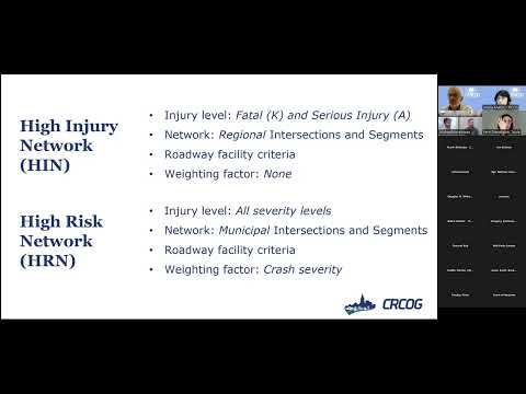
The presenters explained two distinct mapping products: a regional high-injury network focused on fatal and serious-injury crashes and town-level high-risk networks that include all severities and apply weighted economics-based measures (referred to in the presentation with the transcript's weighting terms). The team described an 80% "equivalent" threshold used to identify the subset of intersections and corridors that account for most crashes in a given geography.
Analysis showed crash concentration in dense urban centers: roughly 40% of crashes occur in about 5% of the region's urban land, while rural areas constitute a majority of land but a smaller share of crashes. Presenters highlighted corridors and centers with clusters of fatal or serious crashes — including Hartford, East Hartford, Manchester and New Britain and specific corridors such as Blue Hills Avenue, Routes 44 and 10, the Berlin Turnpike and Main Street in East Hartford. The team also noted that Route 6 has a pattern with relatively many fatalities.
Timing and user-type patterns were discussed: commuter hours produce many crashes in suburban and urban areas, rural areas showed higher crash shares in overnight/early-morning hours, pedestrians were concentrated in urban crashes, and bicyclist crashes were more common in suburban places. The team also reported that people aged 20–34 account for a majority of fatal and high-injury crashes in the region.
Consultants said the regionwide data viewer and individual town handouts will be posted on CROG's website so municipal staff can zoom into intersections and corridors and overlay other information. "We have almost 500 responses so far," the team said of the public survey, and staff urged attendees to distribute the map-based survey in their communities to improve coverage.
Public feedback themes the consultants listed included speeding, aggressive driving, illegal maneuvers, and concerns about crossings and connectivity across the Connecticut River that affect access to jobs and services. The team described upcoming engagement: focus groups with youth and vulnerable groups, AARP outreach to older adults, Table Talk neighborhood discussions (with small stipends), and school-focused events such as a Silver Lane Elementary bike-bus kickoff and a Bike to School week event at Smith STEM on May 8.
Roger said the presentation will be repeated the next day, the recording and slide deck will be made available, and Elizabeth Sanderson, the grant coordinator mentioned during the meeting, is a contact for more information. The team confirmed an SS4A-related workshop set for April 26 at 11 a.m. and offered to meet one-on-one with towns to review maps and underlying data. Morehouse said the project aims to deliver a draft to the Federal Highway administration by early June and a final report by December.
No formal policy votes or motions were taken during the session; the meeting was an informational briefing and a request for municipal review and public input.