Get Full Government Meeting Transcripts, Videos, & Alerts Forever!
Get email alerts on the Pavement Management topic
No spam. Unsubscribe anytime.
Citrus County approves contract to map roads and buy pavement-management software
Summary
Mott MacDonald told Citrus County commissioners it will deliver a pavement-management program using sensor vans and Trimble software; the three-year contract covering surveying, licensing and consulting is about $1 million and funded with ARPA, the presenter said.
CITRUS COUNTY — Mott MacDonald project manager Katia Delgado told Citrus County commissioners that the firm will complete a countywide pavement-condition survey and configure Trimble Pavement Manager software to help the county prioritize resurfacing and budget needs.
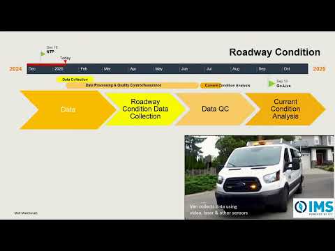
Delgado said two sensor-equipped vans are driving every county-maintained paved road to collect high-definition video, laser measurements and other condition data. "You'll actually have with the high definition video, you'll have, sort of your own Google Street View, of the county roads available," she said.
The three-year contract covers the pavement survey, Trimble software licensing and consulting services. Delgado described the contract sum as "just under $1,000,000," and an unnamed commissioner told the panel that the county is funding the work with ARPA dollars rather than road funds.
Delgado said county staff will purchase the Trimble license directly and Mott MacDonald will perform system configuration, calibration and training. "The software is the counties. The license is purchased directly by the county with, with Trimble," she said, adding that Mott MacDonald will remain on contract to support configurations and onboarding for an agreed period.
She laid out a timeline in which data collection is nearly half complete and expected to finish in mid-February, with data processing and quality control through the spring leading to a mid-summer snapshot of the network. The configured software should be live by early fall, she said, after calibration to align software outputs with staff expectations.
Commissioners asked about long-term maintenance and the pace of repairs. One commissioner said it could take 15 years to bring the network to the desired standard; Delgado pointed to examples such as Polk County where licensing and institutional procedures allowed continuity beyond individual staff changes. "When I left the county, the system still stands and runs," she said of her prior work.
Commissioners also pressed whether the system accounts for traffic types that accelerate deterioration, such as heavy garbage trucks or construction vehicles. Delgado said the discovery sessions with staff will gather traffic counts, GIS flood data and local knowledge to incorporate load and flooding considerations into treatment decisions.
Commissioner Kennard praised the presentation as substantive and said he looks forward to the final report. The project will produce operating procedures and staff training so county staff can run analyses to estimate backlog, budget needs and "what-if" funding scenarios.
Next steps: data collection will be completed and processed, county staff will continue discovery sessions with Mott MacDonald, and the county will proceed with Trimble licensing and software configuration ahead of an early-fall go-live and two years of vendor support.