Lifetime Citizen Portal Access — AI Briefings, Alerts & Unlimited Follows
Census webinar shows how to find complex geographies on data.census.gov
Loading...
Summary
The U.S. Census Bureau hosted a recorded webinar demonstrating how to use data.census.gov to find complex geographies — including summary levels, within‑other‑geographies, remainders, tribal areas, voting and legislative districts — and invited users to training and usability testing.
The U.S. Census Bureau on Monday held a recorded webinar explaining how users can locate and interpret complex geographic units on data.census.gov, with demonstrations for summary levels, within‑other‑geographies, remainders and tribal and voting units.
Noemi Mendez, of the Census Bureau’s Center for Enterprise Dissemination, led the presentation and urged attendees to confirm that the geographic selections they make match the analytic unit they need. "Geographic entities are the areas or boundaries that are used for collecting and organizing data," she said, noting that summary levels specify hierarchical tabulation units separate from FIPS codes.
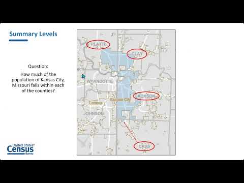
Why it matters: geographic selection affects which population or territory a table describes. Mendez used several concrete examples to show common pitfalls — for instance, Kansas City, Missouri, spans four counties, and using summary level 155 (county within place) helps extract the parts of the city within each county. She also contrasted selecting geographies that are "fully or partially within" a larger unit (which returns entire geographies even if they cross state lines) with using "part" summary levels that return only the overlapping portion.
The webinar demonstrated practical steps inside Advanced Search on data.census.gov: choose All Geographies, pick a summary level (examples used included 155 and 70), then select the state and place and add a table such as B01001 (age). "When you get data for these geographies, you're getting data for the entire geography," Mendez said, emphasizing that the platform returns the full geography associated with a selection unless the user chooses a summary level that isolates the overlapping part.
Mendez covered geographic components such as urban and rural delineations — which the Census defines after each decennial census — and showed how to add geographic component filters and open tables to view urban-versus-rural breakdowns. She also walked through locating economic places, state legislative districts (noting Nebraska’s unicameral exception and how the District of Columbia is represented), voting districts tied to decennial redistricting products (for example table P1), and specialized tribal geographies, including federally recognized reservations and statistical areas.
The session included a step‑by‑step demonstration of the "remainder" concept (summary level 70), using Topaz Lake CDP in Douglas County, Nevada, as an example: a remainder returns the part of a county subdivision that remains after listed places are removed. "A remainder is...the area that's left over after specific portions of the larger geography are removed," Mendez said.
The webinar closed with links to resources, monthly workshops, video tutorials and contact points for follow‑up. Mendez encouraged attendees to submit questions through the Webex Q&A panel during sessions and to email census.data@census.gov for data questions or ced.cedsci.usability.list@census.gov to volunteer for usability testing.
The Census Bureau intends to post the webinar recording and materials on its training pages and Census Academy; attendees were asked to complete an evaluation that opens after the Webex session closes.