Get Full Government Meeting Transcripts, Videos, & Alerts Forever!
Merced City planning commission approves large‑lot map and five Phase‑1 subdivision maps for Virginia Smith Trust project
Summary
The Merced City Planning Commission on Jan. 21 unanimously approved a large‑lot map and five phase‑1 tentative subdivision maps implementing the Virginia Smith Trust specific plan, moving forward infrastructure, school and park sites and requiring conditions including a roughly 1‑acre police/fire site and a relocated water well.
The Merced City Planning Commission unanimously approved a large‑lot map and five phase‑1 tentative subdivision maps for the Virginia Smith Trust (VST) specific plan at its Jan. 21 meeting, advancing a series of maps that together implement previously adopted entitlements and the project’s development agreement.
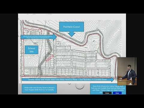
Senior Planner Francisco Mendoza told the commission the VST site covers about 655 acres on the city’s northeast side and was annexed in 2024. The large‑lot map approved Tuesday would divide the site into 53 large lots with a remainder parcel reserved for Phase 2. Staff said the overall specific plan designates roughly 400 acres for residential uses, about 45 acres for commercial, roughly 115 acres for parks and open space, about 20 acres for schools, and roughly 80 acres for roads and other infrastructure.
Mendoza said staff recommended reuse of the environmental analysis prepared for the annexation under CEQA Section 15162 and conditioned approval on a package of draft conditions. Among the conditions discussed were a requirement that the large‑lot map be recorded before any small‑lot maps can be recorded; a staff‑recommended modification to the acreage for a city police/fire site (staff and the applicant discussed setting the site at approximately 1 acre rather than a fixed 1.0 acre); and a condition allowing relocation of a planned water well from Phase 1A to a different lot within Phase 1E in coordination with public‑works engineering.
The applicant’s project manager, Steven Peck of Peck Planning and Development, said the maps…
Already have an account? Log in
Subscribe to keep reading
Unlock the rest of this article — and every article on Citizen Portal.
- Unlimited articles
- AI-powered breakdowns of topics, speakers, decisions, and budgets
- Instant alerts when your location has a new meeting
- Follow topics and more locations
- 1,000 AI Insights / month, plus AI Chat