Neighbors press Santa Rosa officials on wildfire, evacuation and traffic risks at El Noca housing meeting
Loading...
Summary
At a city‑led neighborhood meeting about the Southeast Santa Rosa Senior Housing Community (El Noca), planners and the applicant outlined a proposal for roughly 275 senior units on about 69 acres and described the CEQA review and required approvals; residents pressed officials on wildfire evacuation routes, narrow local roads, wetlands and water.
Serena Lino, the city’s administrative services officer for planning and economic development, opened a neighborhood meeting on the Southeast Santa Rosa Senior Housing Community — commonly called El Noca — and said the forum was for information and public input, not for decisions.
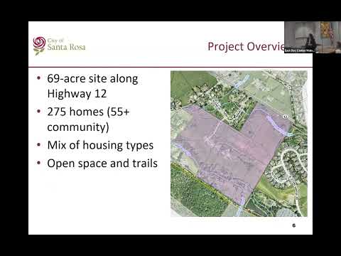
Senior planner Kristine Toomeyans told attendees the project is roughly a 69‑acre site along Highway 12 under review and would require environmental review under CEQA (she referenced the process using “section 15183”). She said requested approvals include rezoning, a tentative subdivision map, use permits, major design and hillside permits, and review by the planning commission and city council. “The city does not design the project, and staff do not make the final decision,” she said.
Vin (Vince) Smith, representing applicant Burbank Housing, walked through a site plan that the team described as a senior (55+) community with a mix of housing types, about 275 units overall and extensive open space and trails. Smith said the proposal “would convert about 34 of those 70 acres into development” while retaining the remainder as open space, and emphasized larger setbacks and landscaped buffers intended to protect neighboring Oakmont homes.
Residents focused their questions on wildfire evacuation, local road capacity and environmental resources. Jay Owens, who lives on Melita Road, warned that the road is “a narrow, windy, heavily wooded road” and asked whether adding project traffic would be “a catastrophe” for his neighborhood. Multiple speakers described Melita as a single‑lane‑width local road and said Highway 12 is the only reliable primary route for mass evacuations.
Santa Rosa Fire and emergency management staff acknowledged the neighborhood’s concerns but said they have worked on refined evacuation tactics since the 2017 and 2020 fires. Division Chief Paul Altahl described coordination with the California Highway Patrol and Caltrans and said the city has contingency plans — including temporarily using both lanes for evacuation and signal coordination — to reduce congestion during emergencies. Altahl also said the parcel is mapped as “moderate” risk under state maps but noted that the city has extended its wildland‑urban interface protections beyond state minimums. “All the homes that are gonna be built in here are gonna be built to current standards,” he said, adding that planned fuel‑reduction measures could reduce some risks.
Other residents conveyed detailed memories from past evacuations. Leo Jones, who said he was evacuated multiple times, described long traffic backups during the Glass Fire and warned that high winds could produce far worse outcomes: “If a 100 mile an hour wind came and drove that fire … we would all be toast,” he said. Several speakers, including environmental scientist Betsy Herbert, urged the city and applicant to take vernal pools, seasonal wetlands and wildlife habitat into account during environmental review.
On circulation and emergency access, staff and the applicant said the proposal includes multiple access points: a primary entrance off Highway 12 and emergency vehicle access (EVA) connections intended to provide fire and evacuation routes into Oakmont and adjacent neighborhoods. Torina Wilson, the city’s transportation planner, said the city requires a traffic study once the applicant submits a complete project and that mitigation for local roads can be required as part of CEQA and plan review. She also noted that decisions about Highway 12 traffic controls (signals, turn restrictions) are ultimately Caltrans’ responsibility.
Residents asked several detailed clarifying questions that staff said will be addressed during the formal review: whether open space would be permanently conserved, how many people would live in the project at build‑out, whether affordable multifamily units would be fully accessible, and whether the applicant would request a state density bonus. The applicant confirmed affordable buildings will include elevators for accessibility and said the density‑bonus request is for processing and certain development standard concessions rather than more units.
City engineering and environmental staff said photos and recent submittals documenting wetlands and creek corridors have been shared with the applicant and relevant regulators (for example, Army Corps/Regional Water Board coordination) and that those resources will be evaluated during environmental review. The city also confirmed the project intends to connect to municipal water (not individual wells).
Next steps: staff said they will continue review, the CEQA‑level environmental document and technical studies will be produced and circulated, and the matter will move to planning commission hearings for recommendation before any city council decision. The city asked attendees to submit written comments via comment cards or by email to elnoca@srcity.org; staff said project notices and postcards will be mailed ahead of public hearings.
This meeting provided the applicant and staff an opportunity to present a revised design and hear community concerns; the formal entitlement record and technical studies produced during environmental review will document the city’s responses and any required mitigation before a final decision is made.