Get Full Government Meeting Transcripts, Videos, & Alerts Forever!
Get email alerts on the Comprehensive Plan Land Use topic
No spam. Unsubscribe anytime.
Powhatan planning commission debates Route 60 buffers, village densities and added industrial sites in comp‑plan review
Summary
At a March 18 workshop, Powhatan County planners and commissioners reviewed proposed changes to future land‑use maps, weighing CWG industrial priorities against housing goals, discussing a proposed 500‑foot commercial buffer along Route 60, transitional parcel categories, and utility extension limits affecting lot sizes.
Powhatan County planning commissioners and staff met March 18 for a workshop to continue reviewing proposed updates to the comprehensive plan’s future land‑use maps, focusing debate on Route 60‑East growth areas, potential industrial expansions flagged by the Citizens Working Group (CWG), village residential densities and transitional buffers.
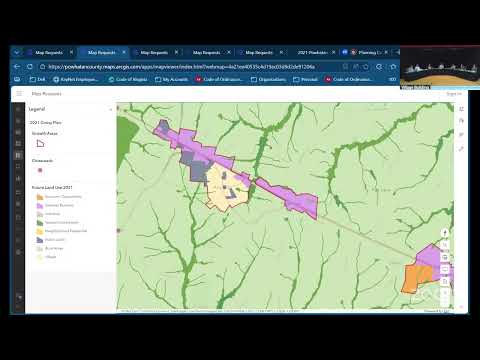
Brian, a county staff member who led the GIS presentation, said the session would “take a deeper dive into the maps” and compared the 2019 and 2021 future land‑use maps to the CWG parcel recommendations. Staff showed how the 2019 map included larger swaths of village residential in the Route 60 East quarter, while the 2021 map reduced village growth areas and narrowed neighborhood residential to a small area near the 7‑Eleven node.
The CWG map added parcels the group said merit further conversation, and commissioners debated whether those red‑outlined parcels, many identified for industrial or economic priority uses, should remain industrial, be reserved for mixed‑use development, or be considered for expanded village residential. One commissioner noted CWG criteria tended to favor larger industrial sites — “large lots over 50 acres,” an approach used in marketing — and asked whether some CWG parcels would better suit mixed‑use scenarios.
Commissioners discussed village‑area density targets and the preferred commercial/residential mixes for new growth. Staff noted the comp plan’s previous village recommendations ranged from about one to two units per acre in the village designation, while “economic opportunity” categories can allow up to four units per acre and recommend a preferred commercial/residential mix (examples discussed included roughly 30/70 or 20/80 commercial/residential splits). Several commissioners said the village core could sustain higher densities than the 2021 map’s two‑unit limit, and pointed to existing zoning tools (village center plan development and village residential plan development) that already allow higher densities in historic cores.
A prominent part of the workshop was a visualization of a 500‑foot buffer on both sides of Route 60 intended to prioritize commercial frontage along the corridor. Staff showed how that setback would compress commercial pads; commissioners debated whether 500 feet was too narrow (some suggested 750 or 1,000 feet) and discussed trade‑offs between small commercial pads and larger gateway business or industrial sites. One commissioner summed up the trade‑off: closer buffers can create smaller, more pedestrian‑scale commercial sites; broader buffers preserve larger commercial/industrial footprints.
Utility availability and extension feasibility emerged as a practical limiter on density. Staff and commissioners emphasized that properties with access to water and sewer could support smaller lots and higher density, while parcels served only by well and septic would likely default to larger minimum lot sizes (a two‑acre minimum was noted several times for septic areas). Participants discussed easements and developer‑funded utility extensions as mechanisms that could enable denser development on some parcels.
Traffic impacts and fiscal effects also shaped the discussion. Some commissioners argued that concentrating industrial or commercial uses without nearby housing would increase commuter and truck traffic from neighboring localities; others said residential development still generates daily trips and that commercial decisions look at surrounding rooftops when evaluating market viability. Commissioners called for more data to quantify trip generation and tax revenue trade‑offs before finalizing map changes.
Several speakers pointed out an existing mismatch between zoning districts (A‑10, RR‑5, R‑2) and comp‑plan density language for rural/royal areas (the comp plan references densities such as one dwelling per 8–10 acres in some rural designations). Commissioners said the mapping exercise should aim for consistency among the comp plan, zoning ordinance, and any overlay or conservation subdivision tools that allow higher densities in targeted locations.
The planning commission did not take substantive formal action on land‑use designations at the workshop. The only recorded motion was procedural: a commissioner moved and another seconded to approve the meeting agenda, and the commission voted to approve it at the start of the session.
Next steps: staff will prepare map examples that apply the discussed options (alternate buffer widths, parcel‑by‑parcel transitional categories, and utility‑based lot‑size scenarios) for review at a follow‑up workshop. The commission scheduled a planning commission meeting April 7 and a workshop on Wednesday, April 22, to continue the land‑use conversation.