Get Full Government Meeting Transcripts, Videos, & Alerts Forever!
Bonner County GIS demos public evacuation-mapping app with 343 predefined zones; officials seek partner feedback
Summary
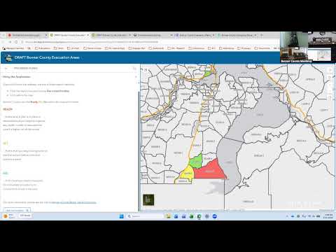
Bonner County GIS demonstrated a public-facing app and an administrative interface that map 343 predefined evacuation zones, arguing maps will reduce public confusion after last year's fires; county officials discussed zone size, on-the-ground validation and who can authorize maps.
At a Bonner County workshop on May 11, the county GIS director, Michael, demonstrated a public-facing evacuation-mapping app and a set of 343 predefined evacuation zones the county plans to use to speed emergency notifications and clarify which properties are in which evacuation area.
Michael said the project grew out of an after-action report from the Flash/Sunset fire and that prose-based evacuation descriptions in brochures had caused confusion. "A map, a picture would clear up all those confusion," he said, and showed a demo where a resident can enter an address or use a phone's location to see their eVAC zone. Michael added that edits to zone status propagate to users in about five seconds.
Why it matters: County staff and responders told the group that unclear evacuation wording delayed public understanding during past fires and that a map accompanying public directions can reduce errors. Officials cautioned that predefined…
Already have an account? Log in
Subscribe to keep reading
Unlock the rest of this article — and every article on Citizen Portal.
- Unlimited articles
- AI-powered breakdowns of topics, speakers, decisions, and budgets
- Instant alerts when your location has a new meeting
- Follow topics and more locations
- 1,000 AI Insights / month, plus AI Chat