Get Full Government Meeting Transcripts, Videos, & Alerts Forever!
Get email alerts on the Bbsp Prototype Blocks topic
No spam. Unsubscribe anytime.
Census trains partners on prototype blocks and GUPS Web ahead of 2030 BBSP submissions
Summary
U.S. Census Bureau trainers explained how prototype tabulation blocks, MAF/TIGER MTFCC codes and must‑hold/do‑not‑hold flags will shape 2030 census blocks, previewed the GUPS Web workflow, and announced participant guides (Jan. 27), a technical webinar (Feb. 5), and GUPS Web release (Feb. 9).
Colleen Joyce, assistant chief of the Census Bureau’s Redistricting and Voting Data Office, walked participants through preparing for the Block Boundary Suggestion Project (BBSP), explaining how prototype tabulation blocks and feature flags will influence the official 2030 census block geography. "When you're doing that you're basically saying that is going to end up a block boundary in 2030," Joyce said of the must‑hold flagging process.
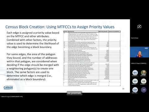
The presentation explained three linked components participants should use to target BBSP work: the MAF/TIGER edges layer and its feature codes (MTFCC), the Census algorithm that forms tabulation blocks from closed polygons and assigns priority values to edges, and the prototype block shapefiles the Census will publish so jurisdictions can triage where to add or remove block boundaries.
Why it matters: census blocks are the smallest decennial geography and they nest inside larger units used for redistricting and many local analyses. Joyce emphasized that while prototype blocks are not final, they give local GIS and redistricting staff advance visibility into likely block geometry and attributes — including land area, a simple shape‑index (area/perimeter) that flags compactness, and a block‑size indicator that estimates housing units (A = largest; I = 1–239; Z = zero units). These fields let partners locate very large, very small, or oddly shaped candidate blocks for targeted edits.
How features affect blocks: the Census forms closed polygons from edges (roads, rail, water, etc.) and then uses MTFCC classifications, whether a feature is named, area thresholds and address counts to decide which edges remain boundaries. Joyce noted two operational flags partners will use in BBSP: must‑hold (if accepted by Census, a flagged edge becomes priority 99 and is very likely to be preserved as a block boundary) and do‑not‑hold (which sets an edge’s priority to zero and makes it unlikely to persist). She cautioned that flags must be placed on features that form closed polygons and that Census staff will review submissions and may reject infeasible requests (for example, trying to remove an incorporated place boundary).
Practical examples: Joyce walked through map examples — bike trails near parallel roads, service drives on a college campus, highway ramps and lakeshore blocks — to show why some linear features survive as block boundaries and others merge away. She recommended common partner actions: add a must‑hold when creating a new, locally important linear feature; use do‑not‑hold to combine tiny zero‑unit blocks into a larger, more useful block; or leave prototype blocks unchanged if they are acceptable for local needs.
Tools and data access: the Census will publish prototype block shapefiles and preloaded partnership files inside GUPS Web; those who prefer to work offline can download FTP partnership shape files by state. Joyce warned the FTP interface can be confusing and urged users to pick the partnership_shape_file_25_version2 files (the transcript and slides call these out as the correct 2025 version). She also noted that when adding or editing linear or area features in GUPS Web, users will select MTFCC and other attributes from dropdown menus and can optionally flag a newly added feature as must‑hold at the time of creation.
Upcoming schedule and next steps: Joyce said participant guides for GUPS Web and for user‑supplied GIS would be released January 27; a technical webinar led by Jenny Carol Levich is scheduled for Feb. 5 at 2 p.m. Eastern; GUPS Web is slated for Feb. 9. Jurisdictions with post‑2022 congressional or state legislative boundary updates must submit Phase 4 changes by an April deadline. Joyce asked attendees to send further questions to rdo@census.gov and said staff will try to package the chat Q&A with the posted recording and slides.
Q&A highlight: Jamie Clark (statewide database) asked whether multiple local partners can collaborate within GUPS Web. Jenny Carol Levich replied that project owners in GUPS Web can designate collaborators who may work and submit directly, or partners can perform edits that the project owner then reviews and submits.
What comes next: jurisdictions should download the prototype block shapefile when it is posted, use the area/shape/size indicators to identify candidate blocks for change, and decide whether to add new linear features, assign must‑hold or do‑not‑hold flags, or wait for subsequent prototype iterations. The Census will re‑run prototype block generation as underlying geography and submissions change leading up to 2030.