Get Full Government Meeting Transcripts, Videos, & Alerts Forever!
Get email alerts on the Flood Modeling topic
No spam. Unsubscribe anytime.
Researchers present Scadget Valley flood model, seek council support for next grant phase
Summary
Experts from the Scadget River System Cooperative described a hydraulic model that shows new 100‑year flood risks, outlined climate scenarios that increase future flood frequency, and asked Cedar Woolly for a letter of support (no direct city funding requested) for a National Fish and Wildlife Foundation grant.
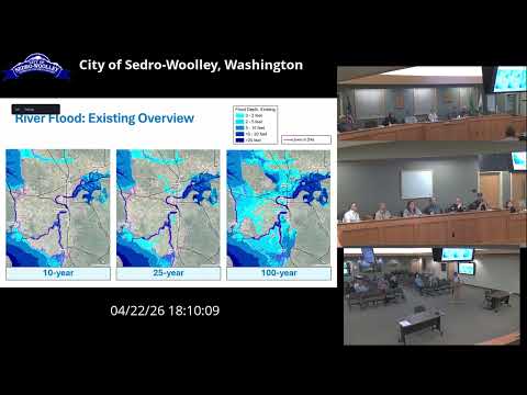
A team from the Scadget River System Cooperative (SRSC) and partners told the Cedar Woolly City Council on April 22 that a new hydraulic model of the Scadget Valley identifies flooding not shown on older FEMA maps and can be used to test adaptation options.
Nora Cammer, representing the SRSC, said the project began after a 2023 grant application and that the effort “received approximately $700,000 in grant funding to develop a hydraulic model” covering the river from New Halum to the saltwater. She said the model is in draft form now and the project team expects a final, stamped engineering report at the end of summer 2026; “yes, the model and its results will be publicly available at the conclusion of the project,” Cammer said.
Why it matters: Council members pressed presenters about two public concerns — whether dredging or other operations (for example reservoir releases) could reduce flood levels, and whether the model can support planning or final engineering. Presenters said the model can be used for planning and to run “what‑if” scenarios such as dredging or changed reservoir operations, but that an engineer‑stamped final deliverable will be needed before jurisdictions should treat the output as a final engineering design.
SRSC staff also described modeled climate futures. Guom Moa of the University of Washington Climate Impacts Group said the team ran present‑day, 2040s and 2080s scenarios and that the results “roughly indicate that the 10‑year event in the 2080s is roughly similar to today's 100‑year event,” a shift that would increase the frequency of damaging floods.
What council was asked to do: Presenters said the next phase — a National Coastal Resilience Fund application to the National Fish and Wildlife Foundation — would fund a web tool to make results broadly usable, additional modeling for upstream reaches, and a pilot, community‑led resilience effort in Cedar Woolly. Steve Mmar, an SRSC adviser, characterized the request as a call for council “support” and staff/community participation rather than a request for direct city funding.
Council reaction and next steps: Members signaled interest and caution. Several councilors said they want access to the final, stamped product before entering interlocal agreements or relying on model output for engineering decisions. The presenters plan a public open house at the end of the summer and said the draft results will remain under a temporary data‑sharing agreement until the final engineering acceptance is complete. If the council chooses, staff recommended providing a letter of support for the full grant application in June, while reserving technical reliance on the model until the final, stamped deliverable is available.