Get Full Government Meeting Transcripts, Videos, & Alerts Forever!
Get email alerts on the Active Transportation topic
No spam. Unsubscribe anytime.
Task force: pedestrian and bike analysis finds inconsistent walking and biking comfort across Fairfax Center core
Summary
Fairfax County staff presented pedestrian (PELOC) and bicycle (BLTS) analyses showing an inconsistent, discontinuous walking and biking network in the Fairfax Center core; applying the county's Active Transportation and Trails Plan (ATP) would improve comfort on many corridors but gaps and right-of-way constraints remain.
Fairfax County transportation staff told the community task force on April 6 that while many sidewalks and bike lanes exist in the Fairfax Center Area, the network is inconsistent and contains gaps and pinch points that make walking and cycling uncomfortable for many users.
"You can get around the core area today, but the network is inconsistent and there are gaps and pinch points that make it less comfortable than it could be," said Ashley Denner of the Fairfax County Department of Transportation during a presentation of pedestrian and bicycle analyses.
Denner said the county measured pedestrian comfort using the pedestrian level of comfort framework (PELOC), where a score of 1 indicates a low-stress environment suitable for all ages and abilities and scores of 4 or 5 indicate uncomfortable conditions or a missing path. Staff identified stretches of Government Center Parkway, Monument Drive and Wexoxox Road that rate poorly due to narrow sidewalks, limited buffers and high speeds. She contrasted Government Center Parkway (PELOC 4: narrower sidewalks, small buffer, 35 mph roadway) with Fairlake Circle (PELOC 1: >8-foot multi-use path and >8-foot buffer with trees) to show how buffer width and tree canopy change perceived safety.
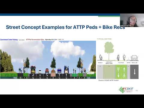
For bicycling, staff used the bicycle Level of Traffic Stress (LTS) framework. Denner said much of the FCA core is currently high-stress for cyclists (LTS 4), with a few striped lanes offering only moderate comfort. Applying recommendations from the county's Bicycle Master Plan and the ATP would raise many corridors ' including Monument Drive, Government Center Parkway and Fairlakes Parkway ' toward lower LTS scores by adding separated cycle tracks or multi-use paths, she said.
Task force members raised practical concerns: several said recommended cross-sections look wide and could require removing mature street trees, raising trade-offs between comfortable shaded walking and preserving existing canopy. "We've seen VDOT/VDOT-like review reject trees in right-of-way because of sight lines," said a participant, prompting staff to note they plan to coordinate plan recommendations with VDOT review and to simulate options with and without trees.
Denner emphasized the ATP provides multiple toolkit options depending on existing right-of-way. For Government Center Parkway she said the existing ROW (127 feet) allows several options and that the ATP often gives multiple acceptable cross-sections for a corridor depending on context and constraints.
Next steps: staff said they will fold this feedback into final recommendations and return with intersection and operations analysis on April 27. The ATP- and bicycle-plan-based options will be refined with right-of-way checks, tree-preservation trade-offs and coordination with VDOT review before they are included in the draft plan guidance.