Get Full Government Meeting Transcripts, Videos, & Alerts Forever!
Get email alerts on the Land Use Density topic
No spam. Unsubscribe anytime.
Auburn committee advances draft high‑growth map after review of state density rules
Summary
The Auburn Comprehensive Planning Committee on Jan. 27 reviewed new state rulemaking tied to LD1829, discussed how 5,000‑square‑foot minimum lot rules and water/sewer availability affect allowable units, adjusted draft high‑growth boundaries (removing watershed‑split parcels) and set the map for public review.
The Auburn Comprehensive Planning Committee on Jan. 27 worked through how recently finalized state rulemaking related to LD1829 will change the city’s draft future‑land‑use map and set a revised high‑growth/high‑density draft to go to public engagement.
Alli Toby, a consultant with Barry Dunn who led the presentation, summarized the two key effects of the rule changes: municipalities must allow some residential development in commercial districts, and in high‑growth areas with public water and sewer the city "cannot [require] minimum lot sizes larger than 5,000 square feet," a footprint that "would have to allow for four units on that lot," she said. In locations that lack water and sewer, statewide Title 12 septic standards would continue to apply, which require roughly half an acre per unit.
The committee heard public comment urging careful boundary decisions. "We need … 1,300 more homes by 2030," said Richard Reynolds, a local real‑estate agent with Home Sweet Main (Keller Williams), arguing the plan should accommodate smaller homes and increased density. Another resident urged the group to avoid shifting active farmland and parcels adjacent to a hospice into high‑growth status.
Committee members said the state rules set a minimum floor for allowable density but do not guarantee that developers will build to that maximum. Members and staff emphasized that local zoning tools — setbacks, building height, form‑based code, and environmental constraints such as wetlands and slopes — still shape what can be built on any given lot. "You can't require substantially more square footage" for additional units beyond the statutory minima, staff said, but local design and site constraints remain relevant.
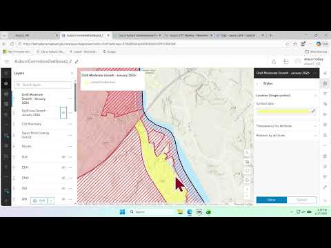
On the map itself, staff said they identified about 851 existing lots of roughly 5,000 square feet or less clustered in downtown and nearby corridors that technically meet the new minimum footprint. During detailed review, the committee directed staff to remove parcel‑split areas where watershed overlays (Lake Auburn and Taylor Pond) divide lots — i.e., where the front of a lot falls inside a high‑growth area and the back lies inside a watershed overlay — and instead treat those parcels as moderate‑growth (yellow) for further consideration. Members also asked staff to square off some irregular boundaries along road corridors for clarity and to maintain obvious non‑developable sites (cemeteries, large institutional parcels) outside the high‑growth designation.
A point of continuing attention is farmland and long‑running agricultural uses. Committee members flagged the West Hard Scrabble Road dairy farm and similar parcels for follow‑up so the city and the planning board can confirm whether adopting Title 7 agricultural protections or alternative policies is appropriate before any zoning changes are made that could affect existing farming operations.
The committee stopped short of final zoning changes. Instead it approved moving a revised high‑growth draft — clipped to parcel and watershed boundaries and reflecting the committee’s targeted edits — forward to the public comment period. Staff said they will finalize policies and actions, reconvene subcommittees in March, brief the planning board in February and present the draft to city council likely in March. A 30‑day state posting is required before a public hearing.
What happens next: staff will prepare the revised map and materials (including visuals showing existing building types) for the public engagement period, and the committee will reconvene to review community input before making final recommendations to the planning board and city council.