Get Full Government Meeting Transcripts, Videos, & Alerts Forever!
Get email alerts on the Coastal Resilience topic
No spam. Unsubscribe anytime.
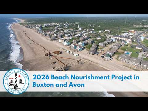
Dare County plans 2026 beach nourishment on Hatteras Island to protect N.C. Highway 12
Summary
Dare County announced a summer 2026 beach nourishment project for Hatteras Island that will widen beaches in Buxton and Avon, repair the Buxton terminal groin, and aim to protect N.C. Highway 12; contractors must finish by Dec. 31, 2026, though daily timing depends on weather and equipment.
A Dare County agency official announced a beach nourishment project scheduled for summer 2026 on Hatteras Island, targeting the unincorporated villages of Buxton and Avon to widen beaches and protect N.C. Highway 12 from storm surge and overwash.
The county said the primary goal is to create a larger buffer between the Atlantic Ocean and the highway by placing new sand along eroding stretches of shoreline. Officials described the work as intended both to reduce roadway vulnerability and to provide wider recreational beaches and additional habitat for wildlife.
Dare County said the precise timing and daily work locations will be set by the contractor and could change because of weather, ocean conditions, equipment availability and other factors. "Contractors are required to complete the work by December 31, 2026," the official said; based on past projects, the county expects nourishment to finish before that deadline.
In Buxton, the county said nourishment is planned along about 2.9 miles of shoreline from the Hallovers Day Use Area on the north end of the village to the terminal groin near the Buxton beach access. A repair of the Buxton terminal groin will be carried out in conjunction with the nourishment; the county said the groin was built to trap sand, reduce erosion and help protect nearby infrastructure including N.C. Highway 12.
In Avon, the county said nourishment is planned along about 2.5 miles of shoreline, from roughly 3,000 feet north of Avon Pier at Dis Road to the National Park Service station or the formal Avon boundary.
Dare County said it will post finalized schedules and progress updates as they become available and directed residents and property owners to morebeachtolove.com to register for project updates. The county-level announcement did not identify an individual spokesperson by name.