Get Full Government Meeting Transcripts, Videos, & Alerts Forever!
Get email alerts on the Coastal Management topic
No spam. Unsubscribe anytime.
Westport launches barrier-beach management plan with public outreach and data collection
Summary
The Town of Westport and consultants from Woods Hole Group and SERPED opened a public kickoff for a barrier-beach management plan covering Atlantic Ave, the Knubble and East Beach Road; the project is funded by the Massachusetts Coastal Zone Management Office and the Municipal Vulnerability Preparedness program and aims to deliver a draft plan by June 30.
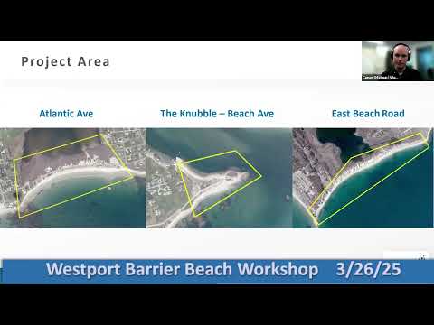
Connor Austin, a coastal scientist with Woods Hole Group, told residents Tuesday that the Town of Westport has begun a rapid planning effort to guide how it manages three barrier beaches — Atlantic Ave, the Knubble and East Beach Road — after storm damage last year.
The kickoff presentation, hosted virtually and facilitated by Kevin Ham of SERPED (the Southeastern Regional Planning and Economic Development District), described field surveys already completed, funding sources and a compressed project timeline. “This project is about understanding existing conditions, looking at vulnerabilities, and developing near-term management recommendations,” Austin said.
Why it matters: barrier beaches are Westport’s first line of defense from storms and rising seas, Austin said. They absorb wave energy, protect inland roads and utilities, shelter harbors and support wildlife and seasonal recreation that contributes to the local economy.
The project and partners: Woods Hole Group is leading technical analysis and modeling; SERPED is leading outreach. Austin named Woods Hole Group staff on the call and identified project funders as the Massachusetts Coastal Zone Management Office and the Municipal Vulnerability Preparedness Program. Mary Jones of SERPED said the outreach program will include surveys, multiple community meetings, in-person tabling at beaches and targeted materials for seasonal residents.
Scope and limitations: Austin emphasized the planning focus. The teams have performed topographic surveys, sediment sampling and wetland mapping in February and March to establish a baseline. He said the project is intended to produce a draft near-term beach management plan by about June 30 and additional outreach in July when seasonal residents return; it is not a construction or permitting effort. “This is a planning project. We aren’t going to physically reduce vulnerability by the end of June,” Austin said.
Local details: Atlantic Ave (where the Elephant Rock Beach Club and a town dune restoration were cited) and the Knubble (a ledge feature at the harbor mouth) were described as having distinct sediment and habitat conditions. East Beach Road was singled out as heavily developed, with utilities and the roadway at risk from repeated storm damage; Horseneck Beach was noted as state-managed (Department of Conservation and Recreation) and therefore outside the town’s management authority.
Questions from attendees focused on the usefulness of data over time, sea-level-rise scenarios and alternatives to nourishment. On data currency, Austin said the project seeks to set a useful baseline for planning rather than supplying permitting-ready data for immediate construction, which can become “outdated” in different contexts. On beach nourishment — “bringing sand onto the beach” — he noted it can be effective but is costly and often requires repeat placement every five to 10 years. On sea-level rise, the team will rely on NOAA tide data for baselines and may test future scenarios but has not settled on specific rates; Austin suggested the team will examine incremental changes rather than only extreme long-term scenarios.
Next steps: attendees were sent into breakout rooms to discuss each beach and invited to complete an online survey and follow-up events. Mary Jones said the project website and emailed updates will carry meeting materials and next steps.
The Town of Westport project team said it will combine the new field data with prior studies — including a 2014 Knubble study and a 2020 East Beach analysis — and an ongoing independent study by Boston University and the Buzzards Bay Coalition of the Gooseberry Island causeway, the results of which were reported as delayed to the end of May. The team plans modeling of long-term alternatives in May and expects to present a draft plan at the end of June for further town deliberation and permitting as needed.