Get Full Government Meeting Transcripts, Videos, & Alerts Forever!
Get email alerts on the Rezoning topic
No spam. Unsubscribe anytime.
Scappoose staff propose rezoning up to 51 acres near airport; councilors raise floodplain and concentration concerns
Summary
City planners presented a package of land‑use efficiency measures including rezoning up to 51 acres near the airport from industrial to commercial, small‑lot and duplex-rule changes, and urban growth boundary options; councilors flagged floodplain fill, potential concentration under one owner, and tradeoffs with industrial jobs.
City planning staff presented a package of land‑use efficiency measures that would reduce minimum lot sizes for duplexes and some middle/multi‑family housing, lower duplex parking from four spaces to two, increase accessory dwelling unit lot coverage, and propose rezoning parcels near the airport as part of an urban growth boundary (UGB) study.
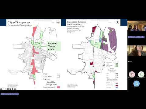
Planner (presenting) said the staff analysis includes a proposal to rezoning roughly 51 acres in the north part of Scappoose (near Highway 30 and the airport) from industrial to commercial, along with smaller changes elsewhere. The planner said the city still has a projected surplus of industrial land—about 140 acres over a 50‑year horizon—so staff did not include industrial expansions in the recommendation; the rezones are intended to address commercial and housing needs inside the UGB.
The advisory committee (SACE) and several council members raised concerns. Committee members worried rezoning both parcels would concentrate much of the city’s future commercial land under one owner and reduce flexibility for a distributed pattern of development. Staff responded that the landowner requested the reszone and described a vision for an “innovation hub” with a mix of commercial, light manufacturing/R&D and housing for faculty and students; staff said assembling both parcels could improve site viability and help attract an anchor tenant.
City Councilor Kim Holmes asked about floodplain and land‑fill status on the subject parcels. Staff said the property is being filled under a DOGAMI permit to about 2 feet above base flood elevation and that the owner plans to submit documentation for a FEMA letter of map revision; once FEMA processes that revision the parcels could be removed from the 100‑year floodplain maps.
Participants discussed engineering controls for fills. Staff described structural fills placed in lifts, compaction and surcharge monitoring to allow consolidation and minimize settlement risk, and cited a prior monitoring exercise near Charles T. Parker Way where surveys showed no appreciable settlement after similar work.
On land‑need numbers, staff said the city has a small commercial surplus under one scenario and a 10‑acre commercial deficit if no rezoning occurs; rezoning only the southern 27‑acre parcel would yield a modest surplus (about 12 acres), while rezoning both parcels (51 acres) would produce a larger surplus (about 31 acres). For housing and public uses the planner reported a deficit: roughly 43 acres suggested for near‑term UGB expansion and about 314 acres of mostly housing need over the next 30 years to be addressed via urban reserves.
Developers and council members discussed parcel scale for anchor tenants. Beth and a developer named Chris said meaningful mixed‑use or major retail uses typically need roughly 20 acres or more; Chris cited local examples (a large retail campus can be 40–75 acres, a Costco footprint with pads often 15–25 acres, and some whole retail centers roughly 25 acres) to illustrate market expectations.
Councilors also asked why staff did not propose rezoning other industrial parcels nearer to town. Staff and another participant, Lori, said the city has invested to make certain industrial parcels shovel‑ready in order to attract higher‑paying industrial jobs, and warned that statewide demand for industrial land is high; they said the city could revisit rezoning if parcels remain undeveloped in the future.
Planner reviewed the UGB/urban reserve process under state rules (priority for exception lands, twice‑the‑need screening and Goal 14 factors such as service costs, environmental and social consequences, and compatibility). Staff said they narrowed study areas based on service economics, proximity to the city, and farm/soil constraints, and ruled out highly constrained areas.
The chair paused the work session to set up the regular meeting and public testimony, noting the landowner was present and would provide comment later. No formal motion or vote occurred during the work session portion recorded in the transcript; staff said the rezoning options and study‑area recommendations will be taken up again at subsequent meetings.
Next steps: staff will continue mapping and the UGB/urban reserve analysis, attendees said the landowner and other members of the public will have an opportunity to testify during the regular meeting, and council direction will guide what parcels (if any) move forward to formal hearings.