Get Full Government Meeting Transcripts, Videos, & Alerts Forever!
Get email alerts on the Groundwater Mapping topic
No spam. Unsubscribe anytime.
Advisory council highlights completion of statewide AEM survey and pushes for integrated groundwater data
Summary
Council members reported completion of a large airborne electromagnetic survey and outlined plans to expand groundwater monitoring, better integrate well logs and stream gauges, and modernize the state water‑withdrawal assessment tool so local data can update model inputs.
Michigan’s Water Use Advisory Council on Monday reported the completion of a statewide airborne electromagnetic (AEM) survey and outlined a coordinated effort to improve groundwater mapping, monitoring and data sharing across state and academic partners.
The council heard that the AEM flight program wrapped up June 2, covering ‘‘just over 14,000 line kilometers’’ of survey lines, and that preliminary electrical‑resistivity profiles already show shallow sands and gravels and deeper clay or bedrock markers useful for mapping aquifers, a council speaker said. The project added flight lines over Alma and Sparta townships at local request to support municipal water‑supply planning.
Those survey results feed into several linked initiatives the council reviewed: a hydrologic enhancement study (HEMI), planned expansions of a statewide groundwater monitoring network, an effort to clean and standardize well‑log locations, and a modernization of the water‑withdrawal assessment tool (WWAT) that will allow users to submit local transmissivity or boring‑log data.
"The airborne electromagnetic survey was completed as of June 2; the image shows the different color lines of the different days they flew and we blew a total of just over 14,000 line kilometers," a council member who presented the survey updates said. The presenter emphasized that the dataset is preliminary and will undergo further cleaning and inversion before broader distribution.
Council members described multiple downstream uses for the AEM and HEMI products: to identify data gaps, to help prioritize new monitoring wells and stream gauges for inclusion in a centralized groundwater data management system, and to inform modeling used in the WWAT. Mina, who summarized recent investments in groundwater work, said about $26.5 million has supported related projects in recent years and that the goal is to make state data products more useful to both internal programs and external researchers.
The WWAT modernization has already published new modeling solutions (Hunt 1999 and Hunt 2003 and other screening tools) and now allows stakeholders to upload supporting site data; a third release slated for early 2027 will add reporting and invoicing features. Council leaders encouraged practitioners who have local transmissivity measurements or boring‑log information to submit them so the statewide tools can be validated and improved.
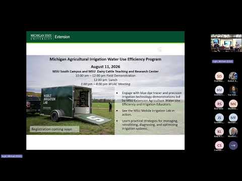
Members also emphasized outreach and demonstration opportunities. A mobile irrigation lab will be demonstrated at Michigan State University on Aug. 11 before the council’s meeting there; staff said the demo is intended to showcase methods for improving on‑farm irrigation uniformity and to let members see field instrumentation in person.
Next steps: project teams will finish data cleaning and inversion of AEM lines, prioritize locations for additional wells and stream gauges based on identified gaps, and continue work to integrate state and externally hosted datasets into a shared user view for policymakers and consultants.
The council scheduled follow‑ups for upcoming meetings and invited practitioners to contribute local data to help calibrate the statewide products.