Get Full Government Meeting Transcripts, Videos, & Alerts Forever!
Get email alerts on the Open Space topic
No spam. Unsubscribe anytime.
Cape Cod Commission outlines regional open‑space plan, highlights water‑supply and floodplain priorities
Summary
Christy Senatore, executive director of the Cape Cod Commission, told the Assembly of Delegates the commission is beginning a regional open space plan that will include interactive maps, community‑by‑community profiles and an economic analysis; staff have met with 12 of 15 towns so far and will post materials as they are finalized.
Christy Senatore, executive director of the Cape Cod Commission, briefed the Cape Cod Regional Government Assembly of Delegates on June 17 about the commission’s early work to develop a regional open‑space plan. Senatore said the commission is compiling interactive maps and community open‑space profiles, and will conduct economic analysis to help towns, land trusts and residents weigh conservation tradeoffs.
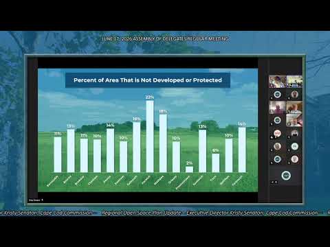
Senatore said the commission’s mapping shows roughly 40% of Cape Cod’s land is protected in perpetuity — about 92,000 acres — and that about 87% of the region is already either developed or protected. “About 40% of The Cape’s land is actually protected open space, about 92,000 acres is protected in perpetuity,” she said, describing federal, state, municipal and other protections on the landscape.
Why it matters: delegates repeatedly pressed for clarity about how the plan will affect local authority, grant eligibility and town planning. Senatore told the assembly the open‑space plan grew from a recommendation in the regional policy plan (approved previously by the assembly) and is meant to be a Cape‑specific tool that coordinates with state goals such as biodiversity conservation and the Farmland Action Plan. She said the plan is not a county ordinance and that many decisions about land use remain local.
Senatore described outreach already underway: "So far, we have met with 12 out of the 15 towns," she said, and staff are vetting open‑space profiles with town staff. She said the commission will post public meeting notices, materials and finalized profiles on its data portal as they are produced.
Delegates asked several practical questions. Delegate Green asked where meeting notices and materials would appear and whether the assembly would need to formally approve the plan when it is finished; Senatore said the commission will update its website with meeting schedules and materials, and that while the assembly approved the recommendation to develop the plan, the open‑space plan itself would not be a county ordinance but the commission would return with updates as the process proceeds.
Senatore also said the commission plans an economic valuation as part of the work to help communities weigh acquisition decisions at town meeting and to provide consistent data for land trusts and local officials. The commission raised potential regional tools under consideration, including an interactive map, regional acquisition parameters, model regulations and exploration of a regional land bank or pooled acquisition resources.
The commission offered to return with regular updates as the plan progresses and to continue town‑level vetting of the profiles and data.
The assembly did not take action; Senatore said staff will follow up with towns and post materials online as they are finalized.