Get Full Government Meeting Transcripts, Videos, & Alerts Forever!
Get email alerts on the Zoning Map Adoption topic
No spam. Unsubscribe anytime.
Committee reviews citywide zoning map and implementation plan ahead of Aug. 1 code change
Summary
Planning staff presented a citywide rezoning plan and map to take effect Aug. 1, 2026, describing new residential (R1–R5), business (B1–B4), manufacturing (M1–M3) and destination districts, an interactive GIS lookup for over 57,000 parcels, overlay toggles (floodplain, airport), and the legal status of nonconforming uses; a resident praised outreach and urged amendments where needed.
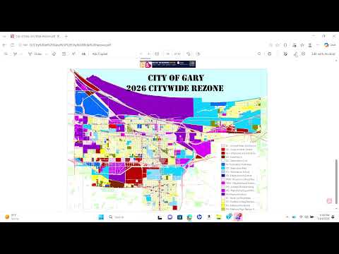
Planning staff gave the committee a detailed presentation on the proposed official zoning map, which staff requested be adopted effective Aug. 1, 2026, concurrent with the city’s new zoning code.
Corey Sharp summarized public engagement (public forum June 4 and outreach since March) and explained that adopting the map would reclassify each parcel under the new code framework—affecting more than 57,000 parcels citywide. Sharp described the residential typology (R1 small-lot through R5 20+ units), business classifications reduced from seven to four (B1 neighborhood to B4 automotive corridor), manufacturing classes (M1–M3, with M3 for heavy industry such as US Steel), and two mixed-use types (neighborhood and downtown mixed-use). Sharp said destination districts (civic, institutional, parks, entertainment) were included and gave examples for clarity.
Staff emphasized that adopting the map changes a parcel’s classification but does not immediately change an existing use; properties that differ from their new classification become legally nonconforming and may continue that use until a change or expansion triggers new standards. The packet and staff demonstrate an interactive map and PDF that will be embedded in the city’s GIS so property owners can look up parcel zoning, height restrictions and setbacks; overlay districts (floodplain and airport) will be toggleable and aligned to FEMA and airport elevation boundaries.
Sharp told the committee the map came out of the plan commission with a favorable recommendation and that staff have been adjusting the map with community input. A public commenter, Miss Carrie, thanked staff and council for outreach, said the new map represented improvements over the prior code and flagged that amendments and overlays remain possible. The committee asked no substantive follow-up questions in the transcript and adjourned after public comment. Staff recommended adoption with the Aug. 1 effective date to align with the new zoning code.