Get Full Government Meeting Transcripts, Videos, & Alerts Forever!
Get email alerts on the Transportation Infrastructure topic
No spam. Unsubscribe anytime.
St. Louis County plans $2.5 million resurfacing and safety upgrades on Barrett Station Road, construction eyed for 2029
Summary
St. Louis County Transportation staff presented plans for a roughly 1.2-mile resurfacing project on Barrett Station Road between Doherty Ferry Road and Big Bend Road, listing pavement repairs, drainage work, new curb ramps and signal upgrades; design continues through 2026, with construction targeted for 2029 and federal reimbursement reducing the local share by about $1 million.
St. Louis County Transportation officials on a public webinar outlined a $2.5 million resurfacing and safety-improvement project along Barrett Station Road from Doherty Ferry Road to Big Bend Road, a roughly 1.2-mile corridor where officials said pavement, drainage and an aging signal need work.
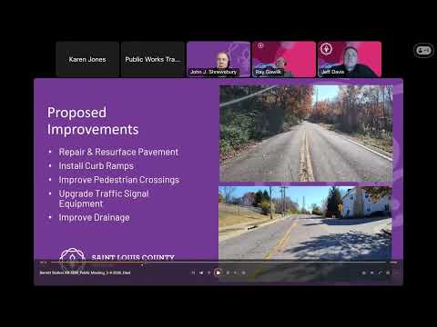
The county presentation said the project would focus on resurfacing, drainage repairs, replacement of a deteriorated headwall and crossroad culvert, targeted sidewalk/ADA curb-ramp replacements, and traffic-signal upgrades at Doherty Ferry that will include flashing yellow arrows and roadside units for emergency-vehicle preemption and data collection. "The anticipated total cost of the project is approximately $2,500,000," the presenter said during the webinar.
County staff emphasized the project is primarily a maintenance and resurfacing effort rather than a corridor-rebuilding scheme. Jeff Davis, project manager supervisor for St. Louis County, said the resurfacing work is being scoped so it could be completed in a single construction season depending on when bidding and contractor scheduling occur. Design work is expected to continue through 2026, right-of-way acquisition is scheduled to begin in 2026, the county expects to bid the project in 2028 and build it in 2029.
Why it matters: The project aims to address immediate safety and asset-condition concerns — including a documented crash history at the Doherty Ferry intersection — while preserving the roadway before conditions worsen. County officials said they successfully secured competitive federal reimbursement for the project, which they expect will reduce the county's local cost by over $1 million.
Scope, limits and local concerns County staff repeatedly told attendees that the project does not include major sidewalk infill or bridge replacement. "This project is scoped primarily as a maintenance project and does not include major improvements such as sidewalk," a county official said, adding that curb ramps and partial sidewalk replacements at specific intersections are included. Staff said the bridge over the creek is inspected on a separate schedule and has no replacement or upgrade scheduled as part of this resurfacing project.
Residents asked whether a fourth crosswalk and signal phase would be added at Doherty Ferry; staff said signal phasing limits the number of signalized crossing legs and they are not showing a fourth crossing at this time. The county has ordered an updated traffic count for the intersection to evaluate whether additional crosswalk legs or other treatments would be warranted.
Pedestrian and bicycle accommodations Staff said they will install rectangular rapid-flashing beacons (RRFBs) and a marked crosswalk to serve the Museum of Transportation, and add accessible pedestrian signals (APS) and high-visibility crosswalk markings at the main intersection. Officials confirmed the ADA minimum sidewalk width is 4 feet (with 5 feet commonly used in new construction and 6 feet used where the sidewalk sits at the back of curb). However, continuous sidewalk through the corridor is not planned under this project because the corridor ranks as a "low impact" priority in the county's walking-and-biking action plan.
Traffic operations and property impacts The county described construction as a moving flagging operation on the two-lane road that should keep homeowners accessable with short delays; full closures are not expected for paving operations. The approach to Barrett Crossing Court will be fully replaced; staff estimated each half of the approach could take about 5 to 6 days (roughly two weeks total) while maintaining access. Officials also described temporary (TSCL) and permanent (PSE) property-rights needs on the project maps and said staff will request necessary rights from owners during right-of-way acquisition.
Safety measures and other local fixes To address a sharp, blind turn and adjacent power pole, staff said they are exploring pavement-marking improvements and potential relocation of the utility pole in coordination with the utility company (Ameren). The signal scope at Doherty Ferry is expected to include new signal heads, backplates and flashing yellow arrows to improve left-turn safety; county staff said crash history supports those changes. Emergency-vehicle preemption devices also are planned for the signal.
Funding and next steps County officials said the project is the product of a competitive funding process; they submitted a 65/35 cost split in the grant application and were successful in obtaining federal reimbursement during construction. Design continues through 2026, right-of-way acquisition is planned to start in 2026, the county expects to bid the project in 2028 and construct it in 2029. Staff will post the meeting recording, preliminary slides and a project information sheet (including RRFB details) on the Barrett Station project webpage and encouraged residents to use the county service-request system to report potholes and other pre-construction issues.
The county closed the webinar after answering chat questions and said staff will continue design and community outreach as the project moves toward right-of-way acquisition and bidding.