Get Full Government Meeting Transcripts, Videos, & Alerts Forever!
Get email alerts on the Gis Aerial Imagery topic
No spam. Unsubscribe anytime.
Carlisle commission authorizes one-year trial of Nearmap aerial imagery for enforcement and planning
Summary
The Carlisle Conservation Commission authorized a one-year trial subscription to Nearmap aerial imagery to improve permit reviews, monitor active projects and speed detection of Wetlands Protection Act violations; the trial will use existing GIS funds to assess cross-departmental value before seeking long-term funding.
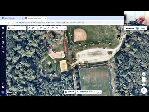
The Carlisle Conservation Commission voted to authorize a one-year trial subscription to Nearmap, an aerial-imagery service the town’s planning staff says will speed permit reviews, allow remote monitoring of active construction and help identify Wetlands Protection Act violations without entering private property.
Megan, the town staff member who demonstrated the tool, told the commission that Nearmap “allows staff to confirm reports of unpermitted work without entering private property” and showed split-view and measurement tools that can document tree removal, new structures and expanded paved areas. She said the quoted price for an unlimited-user subscription was $8,300 annually and that the town has about $42,000 left in GIS program funds to cover a pilot year.
Commission members asked about imagery frequency, accuracy and privacy. One member noted that many communities receive imagery multiple times per year; Megan and others said Nearmap typically flies multiple times annually and provides higher-resolution, GIS-ready measurements than consumer maps. On privacy, commissioners noted that the service uses publicly captured imagery and that any high-resolution layers would be available only to staff accounts when integrated into the town’s AccessGIS.
The board moved and seconded a motion to authorize the one-year subscription trial and proceeded to a roll-call vote. The motion carried and staff said they would test the product across departments and evaluate whether to include it in future budget requests to town meeting.
The trial funding will come from the GIS program’s remaining balance; staff said the pilot is intended to show a cross-departmental value-add before seeking a longer-term appropriation.
The commission concluded the discussion and moved on to the next agenda item.