Get AI Briefings, Transcripts & Alerts on Local & National Government Meetings — Forever.
Conservationists push for wildlife bridge across I‑10 to reconnect Tucson and Tortolita mountains
Loading...
Summary
Speakers described camera and roadkill monitoring showing limited wildlife crossings across I‑10 and urged Pima County and partners to pursue a large crossing spanning the interstate, frontage roads and railroad; presenters also highlighted an existing successful bridge on Oracle Road and a new Santa Cruz River wildlife ramp.
Jessica Moreno, conservation science director with the Coalition for Sonoran Desert Protection, outlined ongoing monitoring and planning work aimed at reconnecting a key wildlife linkage between the Tucson and Tortolita mountains and urged coordination with Pima County and state agencies to build a large crossing near the I‑10 corridor.
Moreno said the coalition’s earlier work at Oracle Road in Oro Valley — which included a wildlife bridge, an underpass and funnel fencing installed during a road‑widening project — demonstrated that crossing structures can “work” and provide multiple benefits. “Wildlife crossings, basically, we’re able to prove with this first bridge and underpass that they work and that they’re successful. So they’re a win win solution for everyone,” Moreno said.
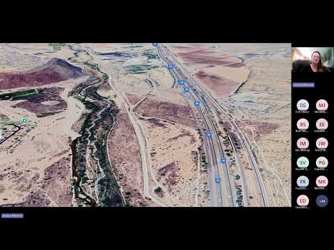
The presentation summarized monitoring results and next steps. The coalition began camera monitoring in 2012 at the Oracle Road linkage and later expanded a separate study, begun in 2017, across I‑10 that now uses stratified camera sites on both sides of the highway to compare species presence. Moreno said the I‑10 corridor currently offers only one potential safe crossing — an abandoned railroad underpass near Avra Valley Road — and that multiple obstacles remain, including the interstate, frontage roads, a railroad, fencing and a soil‑cement levee at the Santa Cruz River.
Moreno described species documented by the coalition and partner agencies: mule deer, javelina, bobcat, coyote, badger, desert tortoise, kit fox, black bear and mountain lion. She said mule deer and desert tortoise are considered key target species for designing a crossing that will be broadly usable. "If we can get deer and we can get desert tortoises across, I think we can get just about anything," she said.
The coalition’s I‑10 study uses 10 stratified sites with multiple cameras at each site, Moreno said, and compares species richness and activity west and east of the highway. She said west of I‑10 (near Saguaro National Park and permanent surface water at El Rio Preserve) camera data show abundant birds, carnivores and javelina, while east of I‑10 the team records more mule deer and jackrabbits. Preliminary daytime roadkill surveys along frontage roads produced few carcasses in an initial seven‑day sunrise survey, Moreno said, but she and others noted that additional, systematic surveys are needed.
Moreno reviewed related projects and engineering efforts. Pima County recently constructed a Santa Cruz River wildlife ramp and associated funnel fencing and is monitoring that site with cameras. Moreno described the ramp as an engineering solution that “allows wildlife to get in and out or past that levee … while still maintaining the purpose of what that levee does for water.” She said the area around the ramp is currently enclosed by funnel fencing to avoid funneling animals to the highway until a full crossing is in place.
On funding and schedule, Moreno said the Oracle Road bridge and underpass were funded in part by the Pima County Regional Transportation Authority (RTA) and that the Oracle project’s budget was publicly reported at about $11 million with final costs closer to $9 million. By contrast, she warned, a new crossing that would need to span the railroad, frontage roads and the interstate would likely cost “several tens of millions of dollars,” and would be less expensive if timed to coincide with any ADOT reconstruction of the I‑10 segment.
Moreno asked partners to consider a mixed funding approach — RTA, federal programs, private donations and pooled funding — and described examples such as the Flagstaff elk project and a California donor model used for the 101 mountain lion crossing. She also emphasized non‑construction needs: open space protection adjacent to crossings, long‑term fence maintenance, coordination with ADOT for permits (the coalition is awaiting an ADOT permit before placing cameras inside the abandoned underpass), and community outreach and education.
Pima County staff and meeting participants asked questions about alternatives to a full bridge, the role of frontage road traffic, and experience on other state projects (SR‑86, SR‑87 and projects on tribal lands were discussed). Moreno said ADOT has discussed future grading plans at the I‑10 site that could present a construction opportunity, but that no timeline or budget is set yet. She also noted lessons from SR‑86 (the Ajo corridor): underpasses and fences were built but long‑term fence and underpass maintenance and flood sediment management remain active concerns.
Moreno said the county will take a coordinating role on follow‑up. “I’m also really pleased too that Pima County is gonna be taking the lead on putting together a working group to see if there’s other places in the county where something like this could be helpful,” she said. Participants were invited to contribute monitoring data (the coalition uses an iNaturalist project and an internal camera dataset) and to join outreach opportunities. One meeting participant said volunteers will perform a frontage‑road cleanup on September 20 and invited attendees to tour the site.
The presentation included repeated calls for combined solutions — crossing structure, funnel fencing, riparian restoration and land protection — and for early coordination so construction opportunities and funding can be aligned. Moreno closed by encouraging broader public participation in planning for the region’s river and flood‑control projects, which can identify sites for future ramps and crossings.