Get AI Briefings, Transcripts & Alerts on Local & National Government Meetings — Forever.
Consultants urge resilience overlays, lower-density zoning for Bayou Liberty and Lacombe study area
Loading...
Summary
A Desire Line study for St. Tammany Parish recommends expanding coastal conservation mapping, creating two resilience zoning overlays and reducing allowable density on large undeveloped parcels in the Bayou Liberty–Lacombe area to limit future flood risk. No ordinance vote was taken; the proposed code changes will be presented next month.
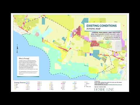
Consultants for St. Tammany Parish presented a coastal resilience and land‑use study at a special parish council meeting, recommending expanded conservation mapping, two resilience zoning overlays and reduced residential density on large undeveloped parcels in the Bayou Liberty and Lacombe study area.
The study area covers parts of Council Districts 7 and 11, roughly bounded by Interstate 12 to the north, Highway 433 to the east and Highway 190 to the west. Desire Line, the consultant team, characterized the area as low and flat, with a combination of coastal and riverine flood sources and aging drainage infrastructure that make the area difficult to drain.
The recommendations are designed to support resilient development rather than an outright ban. “Thirty‑eight percent of the study area is in a critical flood plain. So this is 1,900 acres of the study area,” Alex Carter, president and CEO of Desire Line and principal planner on the project, told the council. Carter said 57% of the study area is in a FEMA flood zone, more than 60% is residential and there are 18 large undeveloped parcels that could be subject to future development pressure.
Why this matters: the report and presentation frame the proposed changes as a response to repeated flooding in the area and to moratoriums on development that the presenters said are set to expire in May. The consultants recommended regulatory tools intended to reduce the number of new lots and require more resilient building methods for new construction in high‑risk areas.
Major recommendations and mechanics
- Extend the parish’s coastal conservation designation northward to include undeveloped land around Ozenwoods, Belterra Acres and what the report lists as Bayou Phuket Estates; amend the comprehensive plan’s future land‑use map to reflect that extension.
- Create two resilience overlays (labeled in the presentation as Resilience Overlay 1 and Resilience Overlay 2). Overlay 1 would be the more restrictive zone for areas subject to higher coastal flood risk; Overlay 2 would be somewhat less restrictive. Overlays would be mapped to individual parcels and can be applied or removed on a parcel‑by‑parcel basis.
- Reduce allowable density on the larger undeveloped parcels in the study area (the presentation contrasted estate districts with one house per seven acres against more intensive suburban lot districts). The consultants said rezoning some undeveloped wetlands as public‑facility/conservation districts would lower development footprints and the need for fill.
- Use overlays to regulate construction standards (for example, elevation and foundation type) and to limit fill depending on parcel location and flood risk.
Process, flexibility and limitations
The consultants emphasized that overlays would apply to new construction; they described a process for property owners who believe an overlay does not apply to their parcel to request a map change. Carter told the council that, in cases where an owner argues a parcel sits on a ridge or has been taken out of the floodplain, the owner would pursue a map amendment or zoning request in the same way other map amendments are handled.
The presenters also noted limits of existing parish tools. Special‑concern and critical‑drainage area designations currently used by the parish require engineered studies and, the consultants said, apply parish‑wide when amended — a constraint the report says reduces flexibility when targeting protections inside the study area. To address those limits, the report recommends the parcel‑level resilience overlay that can be applied or removed individually.
Data and community feedback
The firm said the full report is about 50 pages and that the first 10 pages summarize the findings; council members were told they would have about a month to review the full document before the ordinance is presented. The consultants said they used FEMA maps, CPRA projections and repetitive‑loss analyses to inform the overlay mapping. Carter said the firm is hosting the mapping in ArcGIS Online and will provide a link so council members and the public can view parcel‑level layers.
Public commenters who live in the study area urged strong protections. “Our home, our property has been in my husband’s family for five generations,” said Donna McDonald of Slidell, who said decades of development practices have increased flooding and degraded local wetlands. James Broadwell, who identified himself as president of the Value Liberty Association, described an instance after a two‑inch rain when “Bayou Liberty came up 2 feet,” and urged the council to act.
Points of dispute and clarification asked during the meeting
A resident raised questions about a cost estimate in the draft materials that listed $12,760 to elevate a home three feet for a $220,000 house. A speaker in the meeting said that number was based on two academics’ older data and that more current construction costs for elevating new construction run roughly $45–$50 per square foot. The consultants acknowledged the comment and said they would work to update that information.
Next steps
No vote was taken at the special meeting. The presenters and council members said an ordinance based on the study will be presented at the next regular council meeting. Staff agreed to circulate the ArcGIS link and the proposed zoning map to council members ahead of the next meeting.
The meeting adjourned after the presentation with a motion to close the special session; the council planned a short break before opening the planning commission portion of the agenda.