Whatcom County tutorial shows how to measure parcel acreage with Adjudication Resources web map
Summary
A Whatcom County Public Works staff member demonstrated how to use the county’s Adjudication Resources Explorer web map to measure parcel acreage and print results for Washington water-right adjudication filings.
A Whatcom County Public Works staff member demonstrated how to use the county’s Adjudication Resources Explorer — the county’s free, public “web map” — to measure parcel acreage for water-right adjudication filings in an online tutorial video.
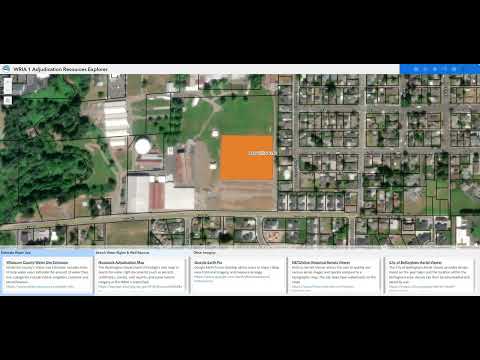
The demonstration, presented in a recorded tutorial, showed how to open the tool from the county homepage, select layers and units, draw a polygon around a parcel and read the area measurement. The presenter used the Linden Fairgrounds as an example and measured a lawn area of 3.17 acres.
The tutorial focused on steps users commonly need when filling out adjudication paperwork: navigate to the Water Adjudication page from Whatcom County’s website, open the Public Works Adjudication Resources web map, use the draw-and-measure polygon tool, set units to acres (or square feet), and enable the “show area measurement” option. The presenter said users can pan and zoom with a mouse or use on-screen toolbar buttons, and cautioned that the map does not save work.
“This is an online, publicly available free mapping tool the county developed for water users in the adjudication,” the presenter said. The video also referenced additional mapping resources available to water users, including a Department of Ecology mapping product with detailed water-right information and third‑party viewers such as Google Earth Pro and the City of Bellingham aerial viewer.
When the presenter drew a polygon on the Linden Fairgrounds example and double-clicked to finish the shape, the web map reported the area as 3.17 acres. The presenter then used the map’s print function to produce a hard copy, noting the print tool offers letter, legal and tabloid (11-by-17) sizes and that printing is recommended because the web map session will not save measurements.
The tutorial also noted that the web map contains multiple layer options (for example, water systems and WRIA 1 subbasins). The presenter explained WRIA stands for Water Resource Inventory Area and that WRIA 1 covers western Whatcom County, parts of northern Skagit County and Point Roberts. For more detailed water-right records, the presenter directed users to consult the Department of Ecology’s adjudication mapping tools and the web map’s help document.
The video closed by reminding viewers the web map includes an instruction/help document with more detailed guidance than the short tutorial and that users should print or otherwise capture measurements because the site does not persist drawn shapes across sessions.
AI generated
The text on this page is AI generated. Summaries, highlights, analysis, and video transcripts are all produced from the original source material.
AI can make mistakes, so if you spot one, and we will fix it for everyone.
Note: the source content is unaltered by us. Any content source we link to, be it a video, an audio recording, or a document, is presented exactly as its publisher released it. That publisher is usually a government body, sometimes an individual official or another organisation.