Get email alerts on the Land Use topic
No spam. Unsubscribe anytime.
Clarke County outlines development plan for Double Toll Gate intersection, secures sewer capacity
Summary
Clarke County released a video explaining a plan to encourage commercial and light‑industrial development around the Double Toll Gate intersection, noting 150,000 gallons of sewer capacity from Frederick Water and recent and pending rezoning of several parcels.
An unidentified Clarke County presenter said the county has produced a short informational video describing plans to spur commercial and light‑industrial development around the Double Toll Gate intersection and the infrastructure steps the county and partners are taking to support it.
The presenter said Frederick Water will provide 150,000 gallons of public sewer capacity for properties within the Double Toll Gate plan area and that sewer service is expected to be available in early 2026. The presenter added that public water is already present in the area but will need to be extended to specific parcels by developers.
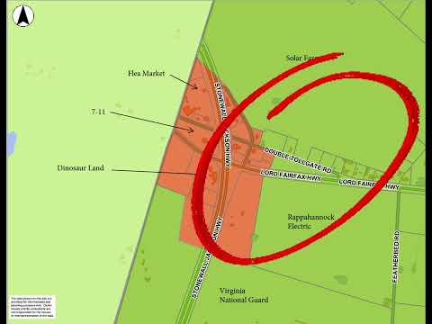
The plan divides the area into three subareas. Subarea A consists of parcels at the intersection already zoned highway commercial. Subarea B covers a 65‑acre parcel owned by Rappahannock Electric Cooperative; according to the presenter, the cooperative plans to build an area headquarters there to serve customers in Warren, Frederick and Clarke counties. The presenter said the REC parcel was recently rezoned to highway commercial.
Subarea C includes the remainder of the former Camp 7 property. The presenter identified three major landowners within that parcel: the Virginia National Guard (154 acres, frontage on Stonewall Jackson Highway and Featherbed Road), the Virginia Department of Transportation (31 acres, including storage facilities and the county trash convenience center site), and the Clarke County Industrial Development Authority (40 acres). The presenter said the National Guard hopes to use its parcel as a regional training facility.
County officials, via the video, said the Clarke County IDA is pursuing rezoning of its 40‑acre parcel to light industrial and is completing property and building studies to determine the most appropriate economic development use. The presenter described the possible outcomes as either one large light‑industrial user occupying the site or subdividing the parcel for multiple users once studies and rezoning are complete.
The video also points out existing landmarks and uses in and around the intersection — including a solar farm, portions of a flea market, an existing '711' and Dinosaur Land — and notes several vacant parcels that could be developed once sewer capacity is available. The presenter closed the short video by thanking viewers.
No formal board votes, motions or timelines for rezoning approvals were presented in the video; the statements are descriptive of current planning, property ownership and anticipated infrastructure availability.
AI generated
The text on this page is AI generated. Summaries, highlights, analysis, and video transcripts are all produced from the original source material.
AI can make mistakes, so if you spot one, and we will fix it for everyone.
Note: the source content is unaltered by us. Any content source we link to, be it a video, an audio recording, or a document, is presented exactly as its publisher released it. That publisher is usually a government body, sometimes an individual official or another organisation.