Lifetime Citizen Portal Access — AI Briefings, Alerts & Unlimited Follows
Grace Evangelical Lutheran seeks to demap portion of 32nd Street to preserve Astoria Lutheran School playground
Loading...
Summary
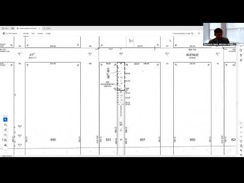
Grace Evangelical Lutheran Church of Long Island City asked the Queens Borough President's land use hearing to recommend demapping a paper street (32nd Street between 21st Avenue and Ditmars Boulevard) so the church and Astoria Lutheran School can retain a playground used by more than 100 students; no vote was taken.
Grace Evangelical Lutheran Church of Long Island City asked the Queens Borough President's Office at a land use public hearing to recommend that the city amend the official map to demap an unbuilt portion of 32nd Street between 21st Avenue and Ditmars Boulevard in Astoria.
"No development activity is proposed by this action," said Ben Stark, counsel for the applicant, describing the demapping as a measure to ensure the site remains available as the Astoria Lutheran School playground. The property at 3120 21st Avenue is owned by Grace Lutheran and the applicant emphasized the parcel has housed the church and school for decades.
Pastor James Klokow said the playground "is so important to us. We couldn't imagine what would happen to the school if we lost the playground because we don't really have any other space for the kids to go outside," noting many students live in apartments without open space.
Stark told the hearing the demapped strip is presently unbuilt and largely used for outdoor school and congregation events; the church previously sold development rights to an adjacent western parcel and that transaction included a light-and-air easement that already restricts construction in the paper-street bed. He said the demapping is intended to add certainty that the Department of Transportation would not later build the street through the playground.
The applicants reported they completed topographical surveys, engaged FDNY, utilities, City Planning and their local council member, and obtained unanimous support from Community Board 1. They also described outreach to the immediate neighbor to the west, who indicated support, and said the nearby Rowan 2 development does not plan a garage entrance or a rear pedestrian entrance facing the demapped area.
Mohammed Sadiq, director of topographical services, asked whether water and sewer utilities run through the map bed toward 21st Avenue and whether resurveying and negotiated access would be necessary; the applicants confirmed utilities likely exist, that resurveying may be required, and that a mapping agreement negotiated with the administration and Law Department will likely grant limited access for agencies such as the Department of Environmental Protection to investigate any historical sewer conditions.
Stark outlined an expected schedule: a City Planning Commission hearing in January, Borough President approval by late February or March if the process proceeds, and a mapping-agreement negotiation that could extend finalization into the summer.
The chair said there were no registered public speakers for the item. The hearing closed without a vote or formal recommendation recorded at the session.