Lifetime Citizen Portal Access — AI Briefings, Alerts & Unlimited Follows
Merced City planning commission approves large‑lot map and five Phase‑1 subdivision maps for Virginia Smith Trust project
Loading...
Summary
The Merced City Planning Commission on Jan. 21 unanimously approved a large‑lot map and five phase‑1 tentative subdivision maps implementing the Virginia Smith Trust specific plan, moving forward infrastructure, school and park sites and requiring conditions including a roughly 1‑acre police/fire site and a relocated water well.
The Merced City Planning Commission unanimously approved a large‑lot map and five phase‑1 tentative subdivision maps for the Virginia Smith Trust (VST) specific plan at its Jan. 21 meeting, advancing a series of maps that together implement previously adopted entitlements and the project’s development agreement.
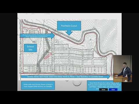
Senior Planner Francisco Mendoza told the commission the VST site covers about 655 acres on the city’s northeast side and was annexed in 2024. The large‑lot map approved Tuesday would divide the site into 53 large lots with a remainder parcel reserved for Phase 2. Staff said the overall specific plan designates roughly 400 acres for residential uses, about 45 acres for commercial, roughly 115 acres for parks and open space, about 20 acres for schools, and roughly 80 acres for roads and other infrastructure.
Mendoza said staff recommended reuse of the environmental analysis prepared for the annexation under CEQA Section 15162 and conditioned approval on a package of draft conditions. Among the conditions discussed were a requirement that the large‑lot map be recorded before any small‑lot maps can be recorded; a staff‑recommended modification to the acreage for a city police/fire site (staff and the applicant discussed setting the site at approximately 1 acre rather than a fixed 1.0 acre); and a condition allowing relocation of a planned water well from Phase 1A to a different lot within Phase 1E in coordination with public‑works engineering.
The applicant’s project manager, Steven Peck of Peck Planning and Development, said the maps implement the previously adopted specific plan and development agreement and that the developer is agreeable to staff’s recommended conditions. Peck said the project provides "more affordable housing than the city standard policy that was appropriate for the location," and explained changes including a slight increase in the fire station site to about 0.93 acres to meet fire‑department layout needs. Senior Planner Mendoza said staff would modify the condition language to specify the police/fire dedication as approximately 1 acre to account for a likely range between 0.9 and 0.97 acres.
Commissioners asked about Campus Parkway and other phasing issues. Mendoza said the developer would construct the portion of Campus Parkway that runs through the project and that extending the expressway to the site is a regional phase tied to funding through MCAG.
Votes at a glance - E‑1: Tentative Subdivision Map No. 25‑0008; Environmental Review No. 25‑0029 (CEQA reuse Section 15162); action: approved 5‑0; conditions: 23 (with modification to Condition 13 to set the police/fire site at approximately 1 acre). - E‑2: Tentative Subdivision Map No. 25‑0007 (Phase 1A); Environmental Review No. 25‑0033 (CEQA reuse Section 15162); action: approved 5‑0; conditions: 40 (modifications to Conditions 8, 18, 31/38 numbering clarified). - E‑3: Tentative Subdivision Map No. 25‑0009 (Phase 1B); Environmental Review No. 25‑0034 (CEQA reuse Section 15162); action: approved 5‑0; conditions: 39. - E‑4: Tentative Subdivision Map No. 25‑0010 (Phase 1C); Environmental Review No. 25‑0035 (CEQA reuse Section 15162); action: approved 5‑0; conditions: 39 (modifications to Conditions 8 and 18). - E‑5: Tentative Subdivision Map No. 25‑0011 (Phase 1D); action: continued to Feb. 4, 2026, on staff request due to an administrative error. - E‑6: Tentative Subdivision Map No. 25‑0012 (Phase 1E); Environmental Review No. 25‑0037 (CEQA reuse Section 15162); action: approved 5‑0; conditions: 41.
What changed or was clarified - Police/fire site: staff and the applicant discussed a practical site area of about 0.93 acres; staff recommended and the commission approved modifying the condition to require "approximately 1 acre" rather than a hard 1.0‑acre figure to accommodate final design. - Water well: staff and the applicant agreed to relocate a planned water well originally proposed in Phase 1A to a different lot in Phase 1E to reduce aquifer draw conflict with nearby irrigation wells; the requirement that a water well be operational in Phase 1 remains part of the sequencing discussion. - Driveway and CFD language: staff proposed edits to Condition 8 (community facility district formation/completion language) and Condition 18 (driveway restrictions along arterial/collector roads, with exceptions for multifamily housing in R‑3/R‑4 zones).
Schools and community facilities Assistant Planner Matt Livingston and a meeting participant described two school sites within the project. Commissioners were told one site is intended for K‑8 use; staff and a participant explained the property is bisected by school‑district boundaries and that both Weaver and Merced City district interests led to the inclusion of two school sites. MCOE involvement and prior purchases of portions of the property for school purposes were discussed as background to those arrangements.
Next steps and timeline Staff noted that if the commission’s actions stand, each approved tentative map will next go to the City Council for final approvals and recording steps; staff emphasized that small‑lot final maps cannot be recorded until the corresponding large‑lot map is recorded. Phase 1D was continued to Feb. 4, 2026, because of an administrative error with the map package.
Representative quotes "This is a big deal, not just in terms of community importance, but geographically, a big project," project manager Steven Peck said, noting the maps ‘‘implement the specific plan, development agreement, EIR and other policies.’" Senior Planner Francisco Mendoza summarized the land‑use split and condition adjustments: "We'd like that [police/fire site] to be modified to approximately approximately 1 acre as we think it'll probably be slightly less than an acre that we'll need." Commissioner Ochoa asked how Campus Parkway would connect; staff said the developer would build the on‑site portion and regional extensions depend on MCAG funding.
The commission adjourned after approving the items and announcing a public workshop on the General Plan update scheduled for Jan. 28.
Ending note All approvals on the record were unanimous (5‑0) where votes were taken; Phase 1D (Tentative Map No. 25‑0011) was continued to the Feb. 4, 2026 meeting for further processing.