Lifetime Citizen Portal Access — AI Briefings, Alerts & Unlimited Follows
Conflict over impervious area and —major development— rules dominates South Street Gardens hearing
Loading...
Summary
Applicant and objectors offered opposing technical views on whether recent site activity and soils mean the project is subject to New Jersey's major-development stormwater rules; applicant engineer's penetrometer testing concluded many areas functionally impermeable and that the proposal reduces net impervious area, while opposition planners/engineers relied on aerial look-back and argued a major-development analysis is warranted.
A central technical dispute at the April 15 Board of Adjustment hearing was whether the South Street Gardens project triggers New Jersey's "major development" stormwater regulations, which hinge on net increases in impervious surface since 2004 and on cumulative disturbance thresholds.
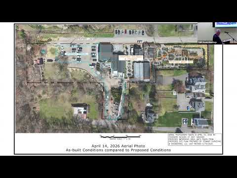
Opponents used historic aerial imagery and an objector's overlay to show areas that, they say, were disturbed and now show compacted or paved surfaces not captured in the applicant's site plan; they argued that the board must scrutinize increases in impervious area and potential wetland impacts. Opposition planner Alexander McLean repeatedly cited the presence of new trailers/containers and increases in impervious cover as material to how the board should decide the D1 variance negative criteria.
Applicant civil engineer Patrick McClellan countered with a forensic and field approach: McClellan said underlying hydrologic soils are poorly drained (hydrologic soil group D) and that penetrometer tests at six rear-site locations produced resistance consistent with the conservation-district definition of low-permeability land. From that, he concluded much of the site historically functioned like an impermeable surface, so the project as proposed would not meet the major-development triggers and in fact reduces net impervious area based on McClellan's baseline.
Both sides agreed the question is fact- and method-sensitive: aerial photos can mislead on surface materials and compaction, but the state regulation explicitly looks back to 2004 and counts highly resistant ground covers as impervious for stormwater purposes. The township's engineer participated in the discussion and accepted the applicant engineer's measurements as an appropriate field technique to inform the board, but the application record now contains conflicting expert opinions the board must weigh.
The board deferred further action and directed discussion of conditions and potential plan revisions at a May 18 continuation. Any final board determination could require additional stormwater calculation, a formal NJDEP filing if a major-development threshold is deemed triggered, or specific resolution conditions requiring site-plan corrections and post-construction inspections.